


By 1837, the Mandans, the Hidatsas, and the Arikaras lived and hunted in a broad piece of the northern Great Plains bounded on the north by the Turtle Mountains, on the south by the Heart River, and on the west by the Yellowstone River. This area included about 12.5 million acres. Of course, the boundaries were not lines drawn on a map.
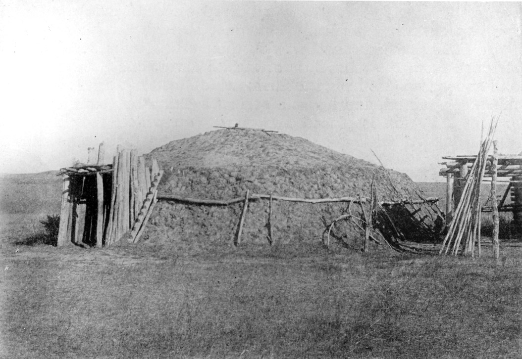
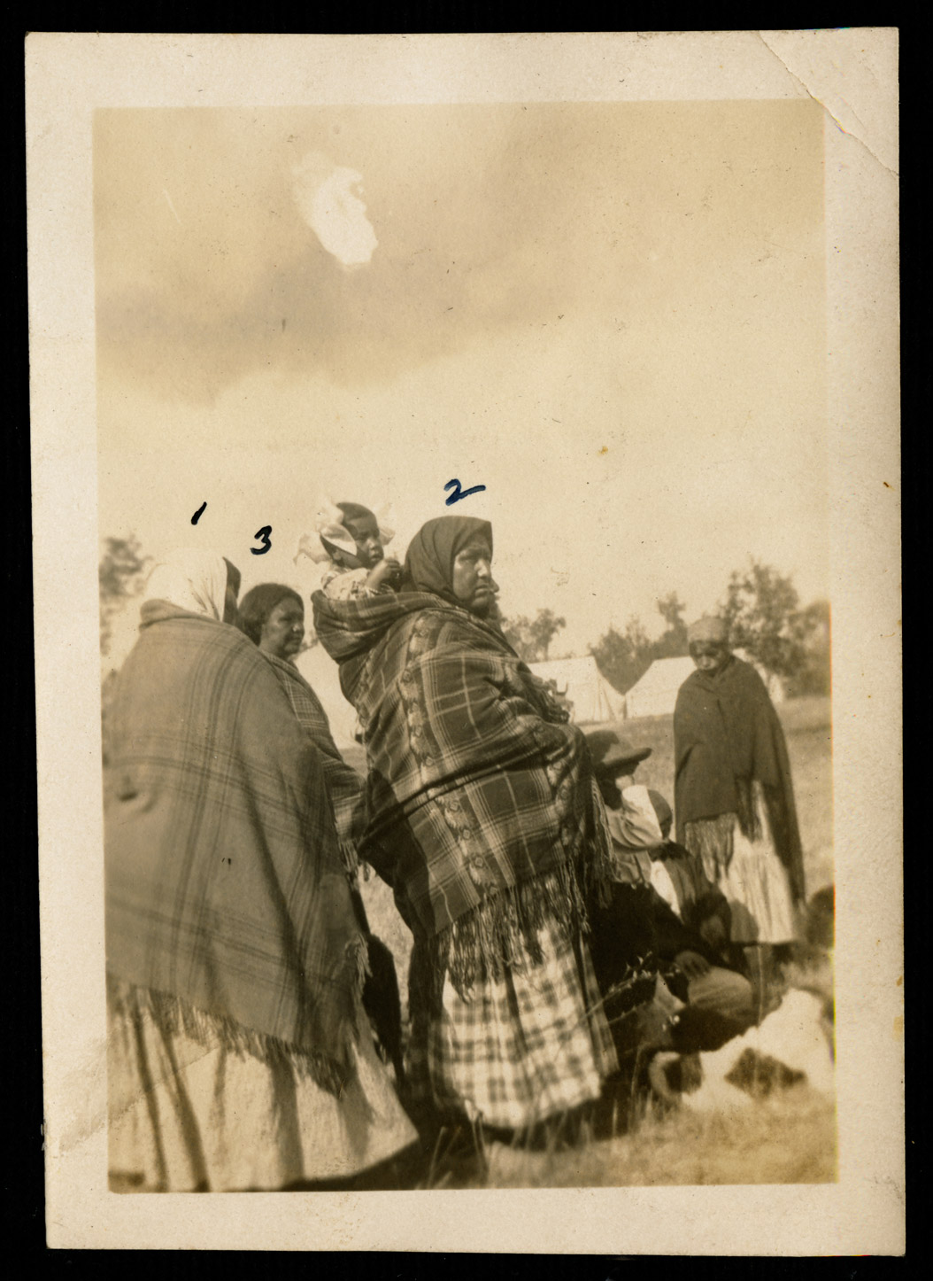
In the mid-19th century, the Arikaras moved nearby (See Image 1). While their winter and summer villages were located near the Missouri River and its tributaries, the tribes hunted bison and collected berries and prairie turnips in the larger area.
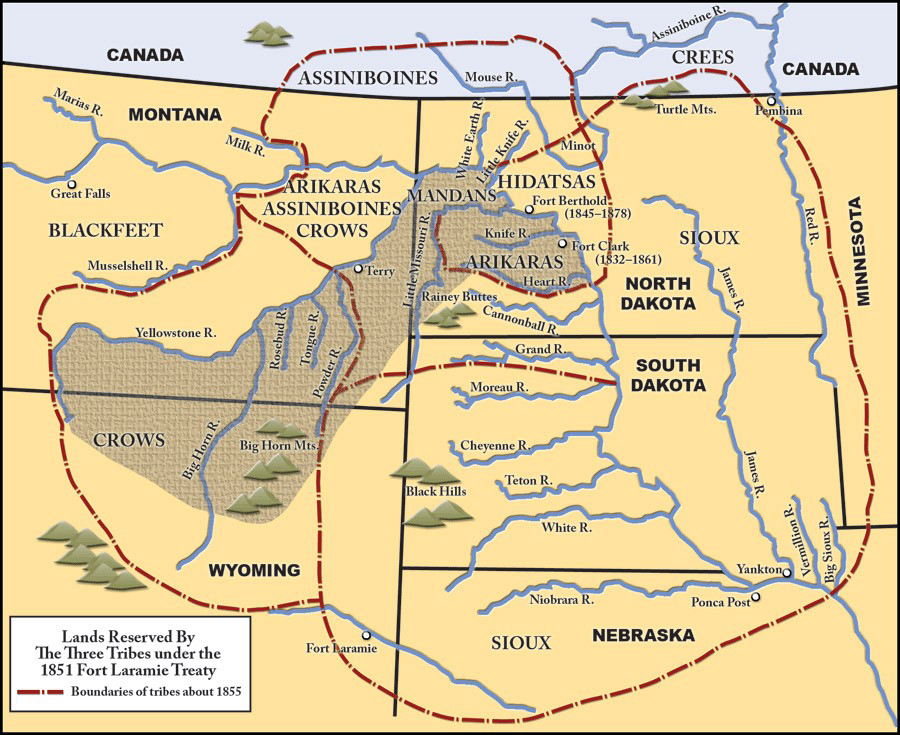
In 1851, the leaders of the Hidatsas (also called Gros Ventres), Mandans, and Arikaras signed the Treaty of Fort Laramie. They had accepted a territory that was just a little smaller than their traditional lands (See Map 1). After the Great Council at Fort Laramie, they returned to their homes at Like-A-Fishhook Village on the Missouri River. The Mandan and Hidatsa maintained their long tradition of commerce at their villages. Twenty to thirty steamboats stopped to trade at the villages every summer. During the 1860s, the U. S. Army established two forts-Fort Stevenson and Fort Berthold (a former fur trade post) on the treaty lands of the Mandans, Hidatsas, and Arikaras.
The steamboats brought some problems to the three tribes. Steamboat crews cut wood to power the boats' engines, but the Mandans, Arikaras, and Hidatsas needed the wood, too. In the late 1860s, the Mandans, Arikaras, and Hidatsas sent a complaint to the Commissioner of Indian Affairs in Washington, D.C., about the loss of wood on their treaty lands. They needed wood to build houses (both earthlodges and the log cabins some lived in) and also for cooking and heating.
In response to their complaint, Captain Wainwright came from Fort Stevenson to listen to the chiefs (See Document 6).
Document 6: Wainwright's Proposal
Document 6. This is a letter from the officer in charge at Fort Stevenson which was located near the homes of the Arikaras, Hidatsas, and Mandans. Following a request from the tribes, Captain Wainwright recommended a reservation for the three tribes. His proposed outlines of the reservation were very similar to those of the Fort Laramie (1851) agreement. The reservation he suggested was big enough “to cultivate and for hunting and grazing purposes.”
Fort Berthold Reserve.
[Occupied by Arikara, Grosventre, and Mandan; area, 1, 382 ½ square miles; established by unratified agreement of September 17, 1851 and July 27, 1866, and act of March 3, 1891 (26 Stat., 1032).]
HEADQUARTERS, FORT STEVENSON,
September 25, 1869.
SIR: I have the honor to report that I have consulted the best guides and obtained all available information in addition to my own examination, as far as it was practicable, in regard to a reservation for the Arickaree, Gros Ventre, and Mandan Indians.
I had an interview with the chiefs of the three tribes, and read the communication from the Commissioner of Indian Affairs, forwarded to me from the commanding general of the department, with which they seemed much pleased. I proposed to them the following reservation, with which they were satisfied: From a point on the Missouri River 4 miles below the Indian village (Berthold), in a northeast direction 3 miles (so as to include the wood and grazing around the village); from this point a line running so as to strike the Missouri River at the junction of Little Knife River with it; thence along the left bank of the Missouri River to the mouth of the Yellowstone River, along the south bank of the Yellowstone River to the Powder River, up the Powder River to where the Little Powder River unites with it; thence in a direct line across to the starting point 4 miles below Berthold. The Indians desired that the reservation should extend to the Mouse River, but in view of a railroad passing over that country I did not accede to their wish. They seemed to comprehend my reason for not doing so, and were satisfied. I have endeavored in this proposed reservation to give them land enough to cultivate and for hunting and grazing purposes. I inclose a sketch of the proposed reservation.
Very respectfully, sir,
S. A. WAINWRIGHT,
Captain Twenty-second Infantry, Commanding Post.
Typescript of the original document collected and verified by Charles J. Kappler:
The Army and the tribes agreed to establish a reservation that was similar to the territory they agreed to in the Fort Laramie Treaty of 1851. The Arikaras, Mandans, and Hidatsas now had a reservation with an agent who was responsible for the well-being of the people (See Document 7).
Document 7: Parker's Response
Document 7. Because Captain Wainwright (Document 6) did not have authority to create a reservation, his recommendation had to be passed on to higher officers and reviewed by The Office of Indian Affairs. The Commissioner of Indian Affairs at that time was Ely S. Parker.Ely S. Parker (1828 – 1895) was the first American Indian to serve as Commissioner of Indian Affairs. He was a Seneca (part of the Iroquois Nation) whose Seneca name was Hasanowanda which means The Reader. Parker had an important role in many of the significant events of the mid-19th century. He was with General Grant at Vicksburg and helped Grant’s staff draft the terms of surrender at Appomattox Courthouse. He worked as an engineer on the Erie Canal. He was elected Grand Sachem of the Six Nations of the Iroquois. He met many refusals in his lifetime because he was an American Indian. Still, when he died, he was buried with full military honors. You can read more about Ely S. Parker at http://www.pbs.org/warrior/content/bio/ely.html Commissioner Parker states that the boundaries of a reservation were identified by the Treaty of Fort Laramie, and that other treaties have followed the same outlines of territory. He recommends that the President (“Executive”) create a reservation for the Hidatsas (“Gros Ventre”), Mandans, and Arikaras (“Arickarees”).
Bvt. Brig. Gen. O. D. GREENE,
Adj. Gen. Dept. of Dakota, St. Paul, Minn.
DEPARTMENT OF THE INTERIOR,
OFFICE OF INDIAN AFFAIRS,
Washington, D. C., April 2, 1870.
SIR: I have the honor to transmit herewith a letter of Capt. S. A. Wainwright, Twenty-second United States Infantry, commanding post at Fort Stevenson, Dak., dated September 25 last, indorsed respectively by the commanding officer of the Department of Dakota and by the assistant adjutant-general of the Military Division of the Missouri, and forwarded by the Adjutant-General of the United States Army to this office, relative to setting apart of a reservation for the Arickaree, Gros Ventre, and Mandan Indians.
This has been the subject of correspondence before between Maj. Gen. Winfield S. Hancock, commanding Department of Dakota, and this office.
General Hancock, in a letter dated near Fort Rice, Dak., July 21, 1869, addressed to Bvt. Maj. Gen. George L. Hartsuff, assistant adjutant-general, Military Division of the Missouri (copy of which has been furnished by direction of Lieutenant-General Sheridan to this office), states that the Arickaree, Gros Ventre, and Mandan Indians, among others, complain “that whites came on their land at Berthold and cut wood for sale to steam-boats. They want this stopped. They are willing that boats should go and cut all they want, but do not want strangers to come and sell their wood while they are starving; they want to cut and sell it themselves.”
General Hancock further states, in the letter above referred to, that he did not know whether those Indians had a reservation or not, and that he has instructed the commanding officer at Fort Stevenson to examine the country about Berthold and to recommend what portions should be set off for them.
By letter dated August 16 last [year] General Hancock was informed by this office that by the treaty concluded at Fort Laramie October 17, 1851, which was ratified, but was amended by the Senate, and the stipulations as amended fulfilled by the Government, the following are given as the boundaries of a reservation for the Gros Ventres, Arickarees, and Mandans, viz: Commencing at the mouth of Heart River; thence up the Missouri to the mouth of Yellowstone River; thence up the Yellowstone to the mouth of Powder River; thence southeast to the headwaters of the Little Missouri River; thence along the Black Hills to the head of Heart River, and down said river to the place of beginning.
A subsequent treaty was concluded with these Indians at Fort Berthold July 27, 1866. This makes no provision in regard to a reservation. The Indians, parties to the same, grant to the United States the right to lay out and construct roads, highways, and telegraphs through their country, and they cede to the United States “their right and title to the following lands, situated on the northeast side of the Missouri River, to wit: Beginning on the Missouri River, at the mouth of Snake River, about 30 miles below Fort Berthold; thence up Snake River in a northeast direction 25 miles; thence southwardly, parallel to the Missouri River, to a point opposite and 25 miles east of old Fort Clarke; thence west to a point on the Missouri River opposite the old Fort Clarke; thence up the Missouri River to the place of beginning.”
This treaty has never been ratified, but appropriations have been made by Congress in accordance with its provisions. There are no treaty stipulations with these Indians relative to a reservation for them which have been ratified.
It is proper here to state that the reservation as proposed by Captain Wainwright is a part of the country belonging to the Arickaree, Gros Ventre, and Mandan Indians, according to the agreement of Fort Laramie, with the addition of a strip of land east of the Missouri River from Fort Berthold Indian village to the mouth of Little Knife River, as shown by the inclosed diagram; and I therefore respectfully recommend that an order of the Executive may be invoked, directing the setting apart of a reservation for said Indians as proposed.
Very respectfully, your obedient servant,
E. S. PARKER, Commissioner.
Typescript of the original documents collected and verified by Charles J. Kappler:
In 1870, the shape of the reservation changed again. The Teton Dakotas had a conflicting claim along the southern border of the Fort Berthold reservation (See Document 8).
Document 8: President Grant's Executive Order
Document 8. Six months after Captain Wainwright’s letter, President Grant ordered a reservation for the “Arikaree, Gros Ventre, and Mandan Indians.” The President used executive order, a privilege that many presidents used in relation to tribal lands. He did not seek approval from Congress.
The president’s diagram no longer accompanies this letter, but you can see the reservation lines in Map 3, 1870. The tribes lost some acreage in this reservation. The most important part of this loss was the area around the mouth of the Knife River where their villages had been located before 1837.
The PRESIDENT.
WASHINGTON, D. C., April 12, 1870.
Let the lands indicated in the accompanying diagram be set apart as a reservation for the Arickaree, Gros Ventre, and Mandan Indians, as recommended in the letter of Secretary of the Interior of the 12th instant.
U. S. GRANT.
Typescript of the original document collected and verified by Charles J. Kappler:
President U. S. Grant signed an order moving the southern boundary of the Fort Berthold Reservation northward and eastward (See Map 2). An executive order did not require the consent of the tribes or Congress.
SHSND 0041-0786.
In 1880, an executive order signed by President Hayes again reduced the size of the Fort Berthold Reservation. When the Northern Pacific Railway (NPRR) reached the reservation in the 1870s, the company asked the federal government to reduce the size of the reservation. The army officers at Fort Stevenson were asked their opinion. Colonel Dan Huston responded that the NPRR had asked for land that was in the traditional and treaty lands assigned to the three tribes for hunting. However, General Nelson A. Miles responded that the tribes had never occupied or hunted on that land. General Alfred H. Terry also supported the railroad’s request.
The Commissioner of Indian Affairs, Roland E. Trowbridge argued that taking the lands from the three tribes would bring hardship to the people of the three tribes. He wrote that “the land west of the Missouri was better for farming and had more timber.” His statements were ignored, and President Rutherford B. Hayes signed the executive order on July 13, 1880 (See Document 9).
Document 9: Hayes' Executive Order
EXECUTIVE MANSION, July 13, 1880.
It is hereby ordered that all that portion of the Arickaree, Gros Ventre, and Mandan Reservations set aside by Executive order dated April 12, 1870, and known as the Fort Berthold Reservation, and situated in the Territories of Dakota and Montana, respectively, lying within the following boundaries, viz, beginning at a point where the northern forty-mile limit of the grant to the Northern Pacific Railroad intersects the present southeast boundary of the Fort Berthold Indian Reservation; thence westerly with the line of said forty-mile limit to its intersection with range line, between ranges 92 and 93 west of the fifth principal meridian; thence north along said range line to its intersection with the south bank of the Little Missouri River; thence northwesterly along and up the south bank of said Little Missouri River, with the meanders thereof to its intersection with the range line between ranges 96 and 97 west of the fifth principal meridian; thence westerly in a straight line to the southeast corner of the Fort Buford Military Reservation; thence west along the south boundary of said military reservation to the south bank of the Yellowstone River, the present northwest boundary of the Fort Berthold Indian Reservation; thence along the present boundary of said reservation and the south bank of the Yellowstone River to the Powder River; thence up the Powder River to where the Little Powder River unites with it; thence northeasterly in a direct line to the point of beginning, be and the same hereby is, restored to the public domain.
And it is further ordered that the tract of country in the Territory of Dakota, lying within the following-described boundaries, viz, beginning on the most easterly point of the present Fort Berthold Indian Reservation (on the Missouri River); thence north to the township line between townships 158 and 159 north; thence west along said township line to its intersection with the White Earth River; thence down the said White Earth River to its junction with the Missouri River; thence along the present boundary of the Fort Berthold Indian Reservation and the left bank of the Missouri River to the mouth of the Little Knife River; thence southeasterly in a direct line to the point of beginning, be, and the same hereby is, withdrawn from sale and set apart for the use of the Arickaree, Gros Ventre, and Mandan Indians, as an addition to the present reservation in said Territory.
R. B. HAYES.
Typescript of the original document collected and verified by Charles J. Kappler: .
The order added some land north of the river. The tribes had lost their traditional homelands, hunting grounds, and sacred sites near the Knife and Heart Rivers.
From 1851 to 1880, the Mandans, Hidatsas, and Arikaras lost more than 12 million acres of their lands. The 1880 reservation was about 10 percent of the land mass the Treaty of Fort Laramie of 1851 had promised them.
Allotment brought another reduction to Fort Berthold (See Document 10).
Document 10: Law of 1891
Document 10. In 1891, Congress passed a law that once again reduced the size of the Fort Berthold reservation. This law is long, but it contains some very important information. Under this law, the Mandans, Arikaras, and Hidatsas were approved for allotment. The Indian owner of the land could not receive title for twenty-five years. This law permits white settlers to claim land within the boundaries of the Fort Berthold Reservation. White settlement could not begin until 1894. The editor has underlined particularly important passages.
SEC. 23 of Chapter 543 of the Indian Department Appropriations Act of the 51st Congress, Second Session, 1891: Indian Department Appropriations
The following agreement, entered into on behalf of the United States, by John V. Wright, Jared W. Daniels, and Charles F. Larrabee, Commissioners, on December fourteenth, eighteen hundred and eighty-six, with the Indians of the Fort Berthold Agency, North Dakota, and now on file in the Interior Department, signed by said Commissioners on the part of the United States and by Pa-des-a-hish and others on the part of the Gros Ventres; and by Wo-ka-se and others for the Mandans and Kun-nukh-to-wite and others on the part of the Arickarees, and is in the following words, to wit:
“This agreement made pursuant to an item in the act of Congress entitled “An act making appropriations for the current and contingent expenses of the Indian Department, and for fulfilling treaty stipulations with various Indian tribes for the year ending June thirtieth, eighteen hundred and eighty-seven, and for other purposes,” approved May fifteenth, eighteen hundred and eighty-six, by John V. Wright, Jared W. Daniels, and Charles F. Larrabee, duly appointed commissioners on the part of the United States, and the Arickaree, Gros Ventre, and Mandan tribes of Indians, now residing on the Fort Berthold Reservation, in the Territory of Dakota, by the chiefs, headmen, and principal men, embracing a majority of all the adult male members of said tribes, Witnesseth that whereas it is the policy of the Government to reduce to proper size existing reservations when entirely out of proportion to the number of Indians existing thereon, with the consent of the Indians, and upon just and fair terms; and whereas the Indians of the several tribes, parties hereto, have vastly more land in their present reservation than they need or will ever make use of, and are desirous of disposing of a portion thereof in order to obtain the means necessary to enable them to become wholly self-supporting by the cultivation of the soil and other pursuits of husbandry:
Therefore, it is hereby agreed and covenanted by the parties to this instrument, as follows:
ARTICLE I.
The Arickaree, Gros Ventre, and Mandan tribes of Indians, parties hereto, hereby cede, sell, and relinquish to the United States all their right, title, and interest in and to all that portion of the Fort Berthold Reservation, as laid down upon the official map of the Territory of Dakota, published by the General Land Office in the year eighteen hundred and eighty-five, lying north of the forty-eighth parallel of north latitude, and also all that portion lying west of a north and south line six miles west of the most westerly point of the big bend of the Missouri River, south of the forty-eighth parallel of north latitude.
ARTICLE II.
In consideration of the foregoing cession and relinquishment the United States shall advance and expend, under the direction of the Secretary of the Interior, the sum of eighty thousand dollars ($80,000), annually, for the period of ten (10) years from and after the ratification of this agreement, for such purposes and in such manner as shall best promote the civilization and well-being of said Indians, and as hereinafter provided.
ARTICLE III.
It is further agreed that the Secretary of the Interior shall cause the lands embraced within the diminished reservation, or such portion thereof as may be necessary, to be surveyed and, either through the agent, or such other person as he may designate, allot the same in severalty to the Indians of the several tribes, parties hereto, in quantity as follows:
To each head of a family, one hundred and sixty acres.
To each single person over eighteen years of age, eighty acres.
To each orphan child under eighteen years of age, eighty acres.
To each other person under eighteen years of age, forty acres.
Provided, That all allotments made under the provisions of this agreement shall be selected by the Indians, heads of families selecting for their minor children, and the agent shall select for each orphan child, and in such manner as to embrace the improvements of the Indians making the selections, if they so desire.
ARTICLE IV.
That upon the approval of the allotments provided for in the foregoing article by the Secretary of the Interior, he shall cause patents to issue therefor, in the name of the allottees, which patents shall be of the legal effect and declare that the United States does and will hold the land thus allotted, for the period of twenty-five years in trust for the sole use and benefit of the Indian to whom such allotment shall have been made, or, in case of his decease, of his heirs, according to the laws of the Territory of Dakota, and that at the expiration of said period the United States will convey the same by patent to said Indian or his heirs as aforesaid in fee, discharged of said trust and free of all charge or incumbrance whatsoever. And if any conveyance shall be made of the lands set apart and allotted as herein provided, or any contract made touching the same before the expiration of the time above mentioned, such conveyance or contract shall be absolutely null and void.
Provided, That the laws of descent and partition in force in said Territory shall apply thereto after the first patents therefor have been executed and delivered.
ARTICLE V.
That upon the completion of said allotments and the patenting of the lands to said allottees, each and every member of said tribes to whom allotments have been made shall have the benefit of and be subject to the laws of the Territory of Dakota in all offenses the penalty of which is death or imprisonment in the penitentiary; and said Territory shall not pass or enforce any law denying any such Indian the equal protection of the law.
ARTICLE VI.
That the residue of lands within said diminished reservation, after all allotments have been made as provided in Article III of this agreement, shall be held by the United States for the period of twenty-five (25) years, in trust, for the sole use and benefit of said tribes of Indians, and at the expiration of said period the United States will convey the same by patent to said tribes in common, in fee, discharged of said trust and free of all charge or incumbrances whatever: Provided, That from the residue of said lands thus held in trust allotments shall be made and patented to each child of said tribes who may be born prior to the expiration of the time during which it is provided that said lands shall be held in trust by the United States, in quantity and upon the same conditions, restrictions, and limitations as provided in Article IV touching patents to allottees therein mentioned; but such conditions, restrictions, and limitations shall not extend beyond the expiration of the period during which the lands owned by the Indians in common are held in trust by the United States.
ARTICLE VII.
It is further agreed that the sum of twelve thousand dollars ($12,000), or so much thereof as may be necessary, of the first installment of eighty thousand dollars provided for in Article II of this agreement, shall be expended in the removal of the agency buildings and property to a more suitable locality, in needed repairs, and in the erection of such new buildings as may be required: Provided, That in the opinion of the Secretary of the Interior the removal of the agency from its present site is desirable. And the balance of said installment, and each subsequent annual installment, shall be expended, except as hereinafter provided, in the purchase of goods, provisions, agricultural and mechanical implements, in providing employees, in the education of Indian children, procuring medicine and medical attendance, in the care and support of the aged, sick, and infirm, and helpless orphans of said Indians, and in any other respect to promote their civilization, comfort, and improvement; and the wishes of said Indians shall be consulted, and govern, so far as practicable, in the expenditure of said money. And in the employment of farmers, artisans, and laborers preference shall in all cases be given to the Indians residing on the reservation who are properly qualified for such positions.
In order to assist the Indians in settling upon their individual allotments, and encourage them in their efforts at self-support, it is further agreed that each family and male Indian over eighteen years of age, when he shall in good faith commence the cultivation of his individual allotment with the intention of residing permanently thereon, shall be assisted in the erection of a comfortable house, and be provided with one cook-stove, one yoke of work oxen, one breaking plow, one stirring plow, one cow, one wagon, one axe, one hoe, one spade, one handrake, one scythe, and one pitch-fork; or, in lieu of any of said articles, such other useful and proper articles as they may require, in the discretion of the Commissioner of Indian Affairs, the cost thereof to be paid out of the funds advanced as per Article II of this agreement: Provided further, That whenever in the opinion of the President the annual installment of eighty thousand dollars provided for in the first article of this agreement shall be found to be in excess of the amount required to be expended in any one year in carrying out the provisions of this agreement so much thereof as may be in excess of such requirement shall be placed to the credit of said Indians in the Treasury of the United States and expended in continuing the benefits herein provided for when said annual installments shall have expired.
ARTICLE VIII.
Hereafter no subsistence shall be furnished any adult male Indian (the aged, sick, and infirm excepted) who does not endeavor by honest labor to support himself, nor to children between the ages of eight and fifteen years (the sick and infirm excepted), unless such children shall regularly attend school.
ARTICLE IX.
The outboundaries of the diminished reservation shall be surveyed and marked in a plain and substantial manner, the cost thereof to be paid out of the first annual installment provided for in Article II of this agreement.
ARTICLE X.
This agreement shall not be binding on either party until ratified by Congress.
Dated and signed in open council at Fort Berthold Agency, in the Territory of Dakota, December fourteenth, eighteen hundred and eighty-six;”
Be, and the same is hereby, accepted, ratified, and confirmed except as to article six thereof, which is modified and changed on the part of the United States so as to read as follows: “That the residue of lands within said diminished reservation, after all allotments have been made as provided in article three of this agreement, shall be held by the said tribes of Indians as a reservation;” and as so modified said agreement is accepted and confirmed: Provided, That this act shall take effect only upon the acceptance of the modification and changes made by the United States as to article six of the said agreement by the said tribes of Indians in manner and form as said agreement was assented to, which said acceptance and consent shall be made known by proclamation by the President of the United States upon satisfactory proof presented to him that the said acceptance and consent have been obtained in such manner and form.
SEC. 24
That for the purpose of carrying out the terms of said agreement the sum of eighty thousand dollars is hereby appropriated, to be immediately available.
SEC. 25
That whenever any of the lands acquired by this agreement hereby ratified and confirmed shall, by operation of law or proclamation of the President of the United States, be open to settlement, they shall be disposed of to actual settlers only under the provisions of the homestead laws, except section twenty-three hundred and one of the Revised Statutes of the United States, which shall not apply: Provided, however, That each settler on said lands shall, before making final proof and receiving a certificate of entry pay to the United States for the land so taken by him, in addition to the fees provided by law, and within five years from the date of the first original entry the sum of one dollar and fifty cents for each acre thereof, one-half of which shall be paid within two years; but the rights of honorably discharged Union soldiers and sailors as defined and described in sections twenty-three hundred and four and twenty-three hundred and five of the Revised Statutes shall not be abridged except as to the sum to be paid as aforesaid.
Source: Indian Affairs: Laws and Treaties, compiled and edited by Charles J. Kappler (originally published in 1903 and 1904 by the Government Printing Office. Now available courtesy of Oklahoma State University digital history project)
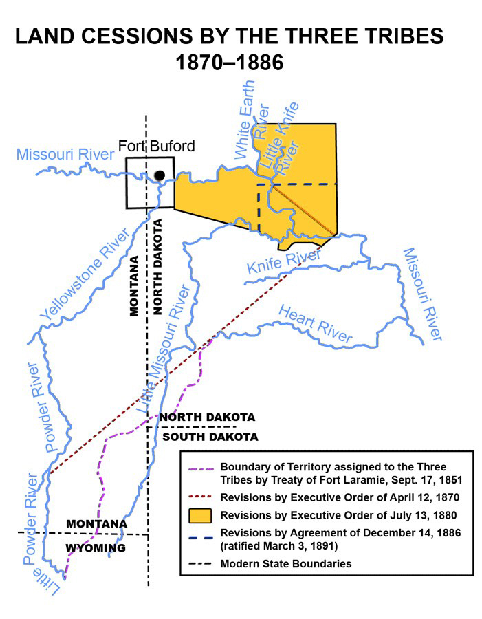
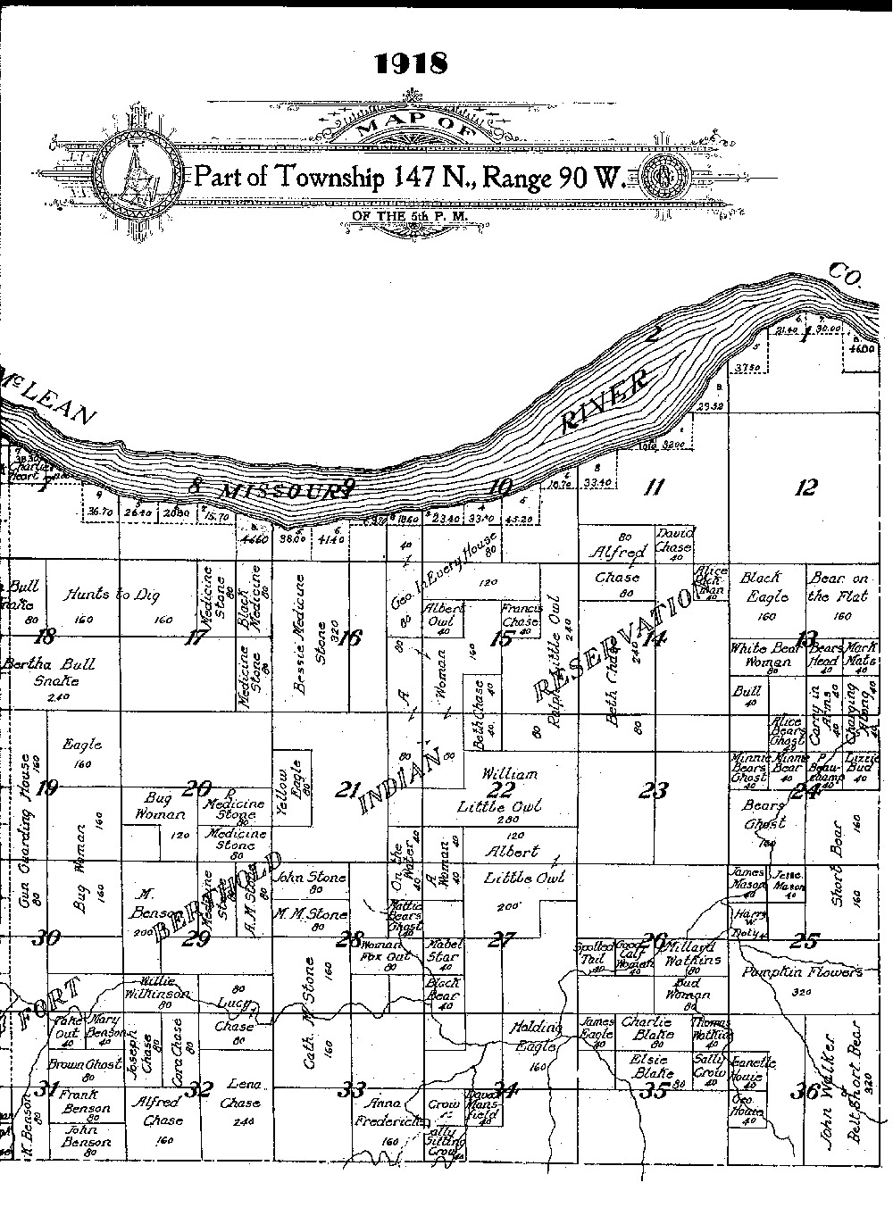
The Mandans, Hidatsas, and Arikaras agreed (were forced to agree) to give up another 1.6 million acres in 1886 (See Image 2).
In 1891, Congress opened those lands for sale to non-Indian farmers (See Document 11).
Document 11: Harrison’s Executive Order
Document 11. In 1891, Congress passed a law giving the President permission to once again reduce the size of Fort Berthold Indian Reservation. In 1892, President Benjamin Harrison signed an order increasing the size of Fort Berthold in one area to compensate for the loss elsewhere on the reservation. This area is a portion of a township.
EXECUTIVE MANSION, June 17, 1892.
It is hereby ordered that the following-described lands, situated and lying in the State of North Dakota, namely, all that portion of township 147 north, range 87 west, lying north of the Missouri River, in the State of North Dakota, not included within the Fort Stevenson military reservation, said State, be, and the same is hereby, withdrawn from sale and settlement, and added to the Fort Berthold Indian Reservation: Provided, however, That any tract or tracts, if any, the title to which has passed out of the United States, or to which valid legal rights have attached under the existing laws of the United States providing for the disposition of the public domain, are hereby excepted and excluded from the addition hereby made to the said Fort Berthold Indian Reservation.
BENJ. HARRISON.
Typescript of the original document collected and verified by Charles J. Kappler:
The three tribes were to receive $800,000 in compensation. The money was not distributed to families, but went to the support of the federal agency, the mission, and reservation schools (See Map 3).
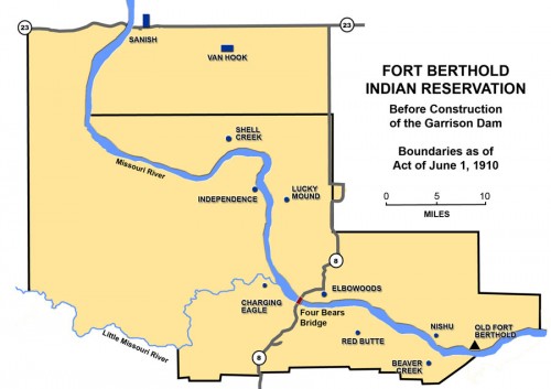
In 1906, Congress considered taking reservation land not allotted and opening it for settlement again. There was strong support for this action in towns just outside of Fort Berthold, but the three tribes disagreed (See Image 3).
In 1910, Congress passed a law allowing the president to open un-allotted lands of Fort Berthold to settlement. The northeast portion of the reservation was divided into sections and sold to non-Indians though the tribes still considered the land to be contained within the boundaries of the reservation (See Map 4).
Why is this important? The loss of tribal lands demonstrates continuing distress in the relationship of the federal government and Indian tribes. Land is a form of wealth in the hands of non-Indian farmers and town developers. However, the federal government did not believe that Indians had the interest or ability to manage the land once the bison herds were gone. Federal officials who lived on the reservation often opposed land-taking and stated that the tribes needed all of their treaty lands and could use that land to make money for the benefit of the people. As tribes lost their lands, the tribes, and individual members, became poorer. Though the Mandans, Hidatsas, and Arikaras protested the loss of their lands, their voices were often disregarded.