Introduction
These resources are written to provide information about the histories and cultures of the Three Affiliated Tribes — the Mandan, Hidatsa, and Sahnish.
The Tribes believe their presence in North America is from the beginning of time. The Mandan call themselves “the People of the First Man.”
The Hidatsa were known as Minnetaree or GrosVentre. “Hidatsa” was formerly the name of a village occupied by these tribes. The term “Hidatsa” became a corruption of the word “midah-hutsee-ahti” translated meaning “house/ lodge made with willows.” The name Minnetaree, spelled in various ways means, “to cross the water.”
Oral and written history says the names “Arikara, Arickara, Ricarees and Rees” were given to them by the Pawnee and other informants to describe the way they wore their hair. The name “Sahnish” is the chosen name used among themselves which means “the original people from whom all other tribes sprang.” For purposes of this guide, the name of “Arikara” and its derivations which appear in treaties and in reference to legal documents will be used to preserve historical accuracy. All other references to these people will use the term “Sahnish.”
Although sharing cultures and histories for so long, the people keep a distinct sense of tribal relationships.
Tribal Historical Overview
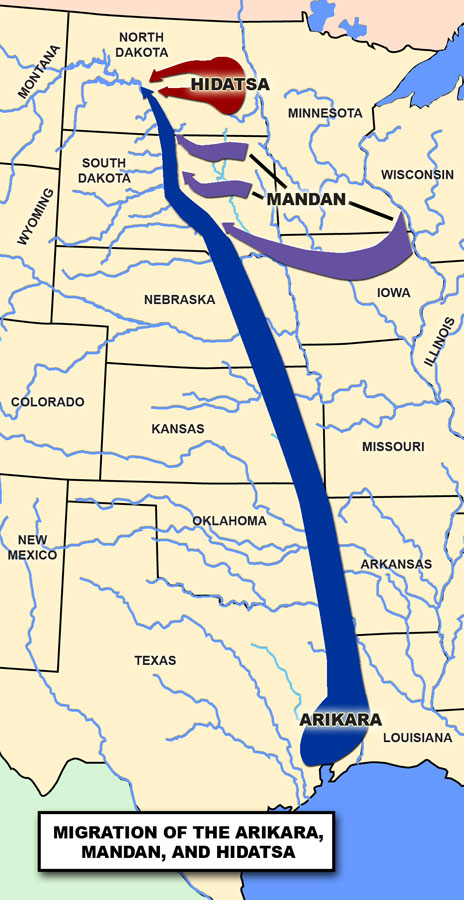
The Mandan, Hidatsa, and Arikara live in the Missouri River area. Historians document the first tribe to occupy this area was the Mandan with the Hidatsa, and the Arikara moving up the river later. One group of Hidatsa came from the east.
The Mandan, Hidatsa, and Arikara have separate and distinct narratives of their origins. The origins of the several bands within each group are separate. The Mandan indicate that there are two prevalent origin theories. One theory is that the Mandan migrated north along the Mississippi River area through southern Minnesota and northern Iowa to the plains in South Dakota. Archaeological findings and carbon dating indicates that the Mandan inhabited a village in the Heart Butte area about 900 A.D. Another theory is that the Mandan originated in the area some distance south of the Scattered Village site in what is now Mandan, North Dakota. The Hidatsa moved from central Minnesota to the eastern part of what is now North Dakota near Devils Lake, and moved to join the Mandan at the Missouri River about 1600 A.D. The Mandan and Hidatsa believe they were created in this area and have always lived here. According to anthropologists, the Sahnish people lived in an area that extended from the Gulf of Mexico, across Kansas, Nebraska, and South Dakota.
Dates of migrations of the Mandan, Hidatsa, and Arikara have been determined by archaeological investigation of village sites constructed along the Missouri River and elsewhere. Many of these sites, although collapsed and abandoned long before, were excavated along the Missouri River during the 1950s and 1960s.
In 1995 the State Historical Society of North Dakota completed the Missouri Trench National Historical Landmark Theme Study that summarized the archaeological investigation of the Missouri River area from southern South Dakota through North Dakota to Montana. Many of the sites were of Mandan, Hidatsa, and Arikara origins.
Ethnographers (people who study cultural societies) group people by the languages they used or were likely to be used by a single group at one time. Indian nations were divided into several linguistic groups. The Mandan and Hidatsa tribes belong to the Siouan linguistic group, along with the Crow, Dakota, Lakota, Yanktonai, Assiniboine, Iowa-Oto-Missouri, Quapaw, and Omaha-Ponca-Osage-Kansa. The Arikara (Sahnish) belong to the Caddoan linguistic group, along with the Pawnee, Caddo, Wichita, Anadarko, Skidi, Tawakoni, and Waco.
This guide links the oral and written histories of the Mandan, Hidatsa, and Sahnish to provide a more accurate viewpoint. The oral tradition preserved the history and ceremonies of the Tribes through a strict and sacred process, thereby adding to the validity of oral tradition.
Trade
Centuries before Euro-American penetration of the Far West, Native Americans had established networks of trails and trade relationships. Prized trade commodities such as marine shells, obsidian, and turquoise were located hundreds, and in some cases, thousands of miles from their origins. Among closely related tribal groups, intra-regional exchange of commodities bearing common social and ceremonial value was well organized throughout the continent. In addition, certain places served as important “trade centers” (Ewers 1968) with routes to other elaborate “trade nets.” (W.R. Wood 1972, 1980)
The tribes of the Mississippi River and the West were linked by a web of commercial relationships prior to European contact. Indian-white trade relations were an outgrowth and creation of Native trade patterns rather those of European design. (Ewers, 1968)

Adapted Wood, Handbook of the North American Indians. (SHSND-ND Studies)
Pre- and proto-historic patterns of Indian trade persisted at traditional primary and secondary centers. Although later modified by European ideas and commodities, inter-Indian trade among the Plains, Southwest, and Great Basin tribes in historic times was significant. (Vol. 9:201-205; Vol. 11:238-255)
It is not clear how many and from what distance separate groups traveled to the trading places of the Missouri River (Bowers, 11950:14-118; W.R. Wedel 1961:181-193), however by 1805 Crow, Assiniboine, Plains Cree, Cheyenne, Arapaho, Kiowa, Kiowa-Apache, and Comanche of the Plains traded dried meat, deer hides, bison robes, mountain sheep bows, and other leather goods for garden produce and Knife River flint at the Mandan-Hidatsa center and were occasionally joined by bands of Teton Sioux at the Arikara center on a regular basis. (Ewers 1968: 17-18; Wood and Thiessen 1985:4-5)
All major trade centers were located among established and sedentary native populations with surplus-abundant economies able to selectively harvest and trade food and other commodities.
On the northern Plains, well before horses and European trade goods intensified the frequency and diversity of intertribal exchanges, a self-sufficient and surplus-abundant trading system as elaborate as that of the Southwest had been long established. The primary focuses of this system were the earthlodge villages of the Mandan-Hidatsa near the mouth of the Knife River in present-day North Dakota, and the Arikara near the mouth of the Grand River in present-day South Dakota.
The geographic location was as a valuable resource as was the craft specialization that enabled the Mandan, Hidatsa, and Arikara to assume the position of middlemen linking riverine horticulturalist with upland hunters. (Ewers 1954; 1968:14-33) This east-west network was labeled the Middle Missouri System. (W.R. Wood 1972, 1980)
Fur Trade
The significance of the fur trade was an involved and complicated part of Indian-white relations. Euro-American efforts to find and extract resources from lands occupied by Indian tribes had its greatest impact on Indian tribes universally.
Among the more extractive industries was the fur trade. (Chittenden 1902; Innis 1962; P.C. Phillips 1961) The fur trade of the Far West extended and was built upon by long established Indian trade networks that involved the exchange of numerous commodities in addition to undressed pelts and hides. Second, there is no single contact experience or pattern of response in the Mississippi River area and the West even within culture areas or among close linguistic relatives.
This relationship was felt in other than economic terms. The ecological impact of commercial fur hunting was greatest on previously stable ecosystems (Wishart 1970; Kay 1979), the cultural impact because of the significance of fur-bearing animals played in the mythology, religious observances, diets, and material cultures of various Native Americans societies.
The trade may well have been the most important meeting round between Indians and whites from first encounter to the beginning of the reservation era. (Peterson and Anfinson 1984)
The role and impact of the fur trade on the Mandan, Hidatsa, and Arikara is succinctly described by author Adrian Dunn in 1969:
“The fur trade era with the Mandan, Hidatsa, and Arikara was the motive for much of the early exploration of the frontier. It was also a prime factor in the destruction of their traditional cultures. The trade in the Upper Missouri became highly competitive, and in their quest for profits, corrupt traders resorted to the most brazen forms of deceit and trickery. Most harmful was the unrestrained use of whiskey in trading with the Indians, who were physically and spiritually defenseless to alcohol. Little regard was shown for the Indians’ welfare by the fur companies, but the damage could not have been nearly so devastating had it not been for the cooperation of the Indian agents of the United States government. The crime of traders, politicians, and other exploiters during this era, was that not only did they steal the Indians’ land, they crushed their spirit and destroyed their cultures.” (Dunn, 1963, p. 235)
Laws and Treaties
Atkinson and O’Fallon Trade and Intercourse Treaty of 1825
The first major treaties made with tribes in this region were made in 1825. A group under Indian Agent Benjamin O’Fallon and General Henry Atkinson traveled up the Missouri River to the Yellowstone with nine keelboats and a large military escort, making treaties with the Teton, Yankton, and Yanktonai Dakota; Cheyenne, Mandan, Hidatsa, and Arikara. In the Atkinson and O’Fallon treaties, also known as the “Friendship Treaties” the Indians acknowledged the supremacy of the United States, which in turn promised them its protection. The tribes, along with the Mandan, Hidatsa, and Arikara agreed not to trade with anyone but authorized American citizens. They also agreed to the use of United States law to handle injury of American citizens by Indians and vice versa. (Schulenberg, 1956, p. 101) On July 18, 1825 the Arikara signed, and on July 30, the Belantse-Etoa or Minitaree Tribe (Hidatsa) and Mandan signed the Atkinson and O’Fallon Treaty.
The 1851 Treaty at Fort Laramie
In 1851, a tribal delegation of Mandan, Hidatsa, and Arikara (Sahnish) accompanied Father Pierre-Jean DeSmet to Fort Laramie to hold council with representatives of the government of the United States. White Wolf spoke for the Mandans, Four Bears for the Hidatsa, and Iron Bear for the Arikara. Colonel M. Mitchell and Major Fitzpatrick represented the government. The boundaries of the Mandan, Hidatsa, and Arikara territory were set-aside in the 1851 Fort Laramie Treaty:
Commencing at the mouth of the Heart River; thence up the Missouri to the mouth of the Yellowstone River; thence up the Yellowstone to the mouth of Powder River, thence in a southeasterly direction to the headwaters of the Little Missouri River, thence along the Black Hills to the headwaters of the Heart River; thence down the Heart River to the place of the beginning. (11 Stats., p. 749, in Kappler, 1972, p. 594, Article 5)
This was the largest treaty council ever held. More than ten thousand plains Indians from the Lakota, Cheyenne, Arapaho, Crow, Mandan, Arikara, Assiniboine, and Gros Ventres (Hidatsa) nations attended. In exchange for $50,000 a year for 50 years, the nations agreed to allow the United States to construct roads and military posts through their country. The tribes also established the boundaries of their territories and agreed to maintain peaceful relations with one another and with the United States. Several tribes, including the Mandans, Gros Ventres (Hidatsas), Crows, Blackfeet, and some bands of the Cheyennes and Araphaos, accepted reservations. (O’Brian, 1989, p. 141)

Under the terms of agreement, the United States would supply the several tribes with $50,000 for 50 years, designate territorial boundaries of each tribe, provide punishment for depredations, and gave authority for the government to lay roads and build military forts in Indian country and other provisions. (Kappler, (compiled and edited) 1904 Indian Affairs, Laws and Treaties, Washington, Vol. II, pp. 594-596)
When the treaty was returned to Washington, the U.S. Senate refused to give its approval to the long term financial arrangements, and amended the treaty by limiting the appropriation to ten years. The Indians were not a part of this amendment and believed the original treaty was still in force.

This monument to Four Bears and others is located near the Three Affiliated Tribal headquarters building at New Town, North Dakota. (Photo by Neil Howe) |
In this form, the Fort Laramie Treaty of 1851 was ratified by the U.S. Senate on May 24, 1852, and the amendment was not sent to the tribes until 1853. While the government secured some signatories to the amendment, in some cases under threat to withhold annuities, the amended document was never approved by all of the tribes concerned. This amendment has been a source of controversy ever since.
Following the Fort Laramie Treaty of 1851, the government established several forts along the Missouri River. In 1864 the cavalry was sent to Fort Berthold and remained there until 1867 when they moved to Fort Stevenson, 18 miles down river. The establishment of forts brought numerous groups up river by steamboat—twenty to thirty steamboats stopped at Like-A-Fishhook Village every summer. By the early 1870s, the railroad had reached the territory of the Mandan, Hidatsa, and Arikara, a bustling economic center for the region.
By 1871, federal Indian policy shifted radically for several reasons. An act of Congress in 1871 “Provided that no treaties shall hereafter be negotiated with any Indian tribe within the United States as an independent nation or people.” Thereafter, all Indian land cessions were achieved by act of Congress or by Executive Order.
Indian societies were being transformed radically from a combination of forces—U. S. Army troops stationed at posts near Fort Berthold after 1864, Indian agency personnel resided on the reservation after 1868, and day schools were being opened on reservations as early as 1870.
Agreement at Fort Berthold, 1866
As more settlers poured into the West the government, pressured by the railroads and settlers for more land, approached the tribes to cede additional lands. On July 27, 1866, the Mandan, Hidatsa, and Arikara signed an agreement by which they granted such rights-of-way to territories east of the Missouri River, and were to receive in return an annuity of $10,000 for the next 20 years. When the treaty was presented for ratification, Congress added an addendum onto this agreement, including the Mandan and Hidatsa in its terms and provided for cession of a tract of land on the east bank of the Missouri River roughly forty by twenty-five miles. (Kappler, 1904-41, report. ed. 1971, Vol. 2, pp. 1052 - 56)
These lands were well below the villages of where the Mandan and Hidatsa were in 1866. Although no longer continuously occupied by them, they used these lands for hunting purposes. These were their ancestral homelands for centuries to which the Arikara settled in 1837. In addition, these lands contained ancient burial sites, and like many cultures considered the area as sacred ground. Congress, however, pressured by the railroad companies, was unwilling to recognize the tribes’ claim to these lands and the treaty was never ratified. (Meyer, 1977, p. 111)
Executive Order of 1870
The Fort Berthold Reservation was established under the Executive Order of 1870. In the late 1860s the Mandan, Hidatsa, and Arikara complained of their wood supply dwindling by whites cutting timber on their lands and selling it to passing steamboats. When the chiefs complained to Washington, a Captain Wainwright, an officer at Fort Stevenson, met with the chiefs. They consented to the establishment of a reservation that included most, if not all, of the territory claimed by them at Fort Laramie in 1851. (Meyer, p. 112)
Because the Sioux had claimed possession of a parcel of the land in question the previous year, the government took off the southern boundary of the Mandan, Hidatsa, and Arikara (Sahnish) territories. The southern boundary of the reservation became a straight line from the junction of the Powder River from the Little Powder River to a point on the Missouri River four miles below Fort Berthold. In order to accommodate the villages then occupied by the Mandan, Hidatsa, and Arikara/Sahnish, the United States government included a strip of land east of the Missouri River. These provisions became legal in the Executive Order of April 12, 1870.
Battle of the Little Bighorn
Some of the bands of the Sioux were on friendly terms with the riverine tribes, but many of the Sioux were openly hostile, and for a hundred years, from 1775 to 1875, the tribes from Pawnee and Otoe in the South to the Mandan, Hidatsa, and the Arikara/Sahnish in the North were constantly under the pressure of Sioux hostility. The Assiniboine and other tribes occasionally attacked the villages, but the Sioux danger was the ever-present problem. These wars were fed willingly by the traders who sold guns and ammunition to both the Sioux and the sedentary tribes.
In the late 1800s and early 1900s the Sioux began to raid the villages of the Mandan, Hidatsa, and Arikara/Sahnish because their sources of food, the buffalo and other game animals, were disappearing with the advancement of white settlers and hunters. The intensity and hostility between the Sioux and the United States Army was leading to war.

In 1874, the Commissioner of Indian Affairs called for Chief Son-of-the-Star to come to Washington, D.C. to meet with him. Son-of-the-Star, Bull Head, interpreter Peter Beauchamp (Arikara); and Bad Gun, Bald Eagle, and Shows-Fear-in-the-Face (Mandans), met with the officials in Washington on several issues and to seek agreement to scout for the military in trade for protection from the vast numbers of Sioux.
In early May and June of 1876, a call was put out for scouts to assist Lt. Colonel George Custer. In 1874, the Arikara scouts, also called “Ree Scouts,” had assisted Custer in Sioux country and the Black Hills. This time it was to find the small, resistant bands of Sioux and bring them back to the reservations. All military reports said these bands of Sioux were in the Montana territory. The agent at the reservations had failed to report that large numbers of Sioux were missing from the reservations.
An accounting of the Ree Scouts surrounding the battle is included in the Appendix. The circumstances that led up to that battle were far reaching and complex. White settlers, backed by military forces, began to encroach on the territory claimed and assigned to the Sioux. Skirmishes followed with the Sioux losing most of the conflicts. On June 25, 1876, the Ree Scouts were involved in the infamous Battle of the Little Bighorn in Greasy Grass, Montana where they were pitted against their historic enemy, the Sioux. The Sioux nations defeated a stunned military force of the government.
Executive Order of 1880
In 1864, when the Northern Pacific Railroad was chartered, it was granted right-of-way 40 miles on either side of the proposed line. This right-of-way went through the lands of the Mandan, Hidatsa, and Arikara/Sahnish. The construction of the railroad reached their lands in 1870s. The Northern Pacific Railroad drew up a resolution asking for a reduction of the reservation. This proposal brought the railroad outside the boundaries of the land grant. When asked about the tribes’ use of the territory, Colonel Dan Huston, commanding officer at Fort Stevenson, asserted that the land in question was the territorial hunting grounds of the Mandan, Hidatsa, and Arikara. However, the response was made by Colonel Nelson A. Miles, stationed at Fort Stevenson, who reported that the tribes did not occupy, nor require the use of the land, and “never had.” The land he said had been reserved for the benefit of the fur traders. (Meyers, p. 113)
Brigadier General Alfred H. Terry, endorsed the railroad company’s request, ignored Huston’s letter, and favored revoking the 1870 Executive Order. The Indian Bureau, represented by Commissioner Roland E. Trowbridge, who came late to the negotiations, wrote to a special agent:
In my judgment, any alterations or change in the present reservation would greatly mitigate against the interests of the Indian. He went on, “the land west of the Missouri was better for farming and had more timber, he said, so giving the Indians additional land east of the river, would not compensate them for the loss.” (Trowbridge to Gardner, April 5, 1880, NARS, RG 75, LS: Kappler, Indian Affairs, vol. 5, p. 745-63, in Meyer, p. 113)
On July 13, 1880, an Executive Order was issued, depriving the Mandan, Hidatsa, and Arikara of the greater part of their lands. Everything south of a line forty miles north of the Northern Pacific Railroad right-of-way was ceded. This involuntary cession also included an extensive tract of land south and west of Fort Buford. The tribes were not consulted when the Executive Order was drawn up. As compensation, the tribes were granted a parcel of land north of the Missouri River, extending to within thirty-five miles of the Canadian border. This action, viewed as bad faith on the part of the government, did not pacify the injured and angry feelings of the Mandan, Hidatsa, and Arikara. The land to the north offered in compensation to the tribes was rough and undesirable. The government believed that because the tribes were confined to an area near their villages, fearful of raids by the Sioux, and the buffalo nearly depleted, they were unable to use the land as they previously had. However, the land had legendary and historic connections for them. This land included their villages on the Knife River, and those villages below on the Missouri River. Within twenty-five years, the government reduced more than 12 million acres of their territory to one-tenth of its original size. (Meyer, p. 113)
Like most Indian claims cases, those pursued by the Mandan, Hidatsa, and Arikara/Sahnish had a long and tangled history. They had never reconciled themselves to the loss of territory resulting from the Executive Orders of 1870 and 1880 for which they had not been compensated. The reductions suffered by the reservation amounted to roughly 90 percent of what the Mandan, Hidatsa, and Arikara/Sahnish had been acknowledged to own at the time of the 1851 Fort Laramie Treaty. The treaty specifically noted that recognition of these claims and did not imply that the Indian signatories should “abandon or prejudice any rights or claims they (might) have to other lands.” The precedent set by the 1880 agreement, together with the history of Indian treaties generally, led the Mandan, Hidatsa, and Arikara/Sahnish to believe that they ought to have been compensated for these reductions. (Meyer, 1977, p. 186)
In 1898, the Mandan, Hidatsa, and Arikara submitted a petition to the President of the United States asking permission to send a delegation to Washington to present their claims. When nothing came from this effort, they tried again in 1911, reminding Washington of the tribes’ history of government relations. A delegation was allowed to come to Washington about a year later. This was to discuss the different interpretations of the terms of the agreement drawn up in 1909 for the opening of the reservation. They were told to get an attorney to pursue their case. Another delegation was sent three years later. The only subject the government would discuss with them was the distribution of proceeds from the land sales following the recent opening of the reservation.

(SHSND-ND Studies) |
Besides the land seizures under the Executive Orders of 1870 and 1880, the tribes now wanted to take up the disposition of the Fort Stevenson military reservation. When the school at Fort Stevenson was closed in 1894, 45,585.75 acres were transferred to the Interior Department. It was sold a few years later for $71,000. The proceeds were placed in the United States Treasury instead of being used for the benefit of the tribes. According to Congress, since Fort Stevenson was established before Fort Berthold, the tribes had no rights to the land. (Meyer, 1977, p. 187)
In 1920, Congress passed legislation conferring to the Court of Claims jurisdiction in the determination of the Three Tribes’ dispute with the government. This act stipulated that a suit must be filed within five years and the attorney’s fees should not be more than ten percent of the amount to be recovered. The first lawyer the Tribes hired was from Fargo, who did nothing but file a petition with the Court of Claims on December 30, 1922. This claim was dismissed on December 17, 1923 and the tribe cancelled his contract.
Charles Kappler and Charles H. Merillat were hired by the Mandan, Hidatsa, and Arikara in 1924. They filed a formal petition with the Court of Claims on July 31 of that year. The evidence prepared by these two men, both documentary and traditional, brought about a court settlement. Because of the impossibility of determining the precise acreage of the territory recognized as belonging to the Three Tribes in 1851, the court settled on a round figure of 13,000,000 acres, from which 11,424,512.76 acres had been withdrawn without compensation, mainly by Executive Orders in 1870 and 1880. From this area were deducted 1,578,325.83 acres added to the reservation by these Executive Orders and that of 1892, leaving a total of 9,846,186.93 acres, for which the Three Tribes were to be compensated at a rate of fifty cents per acre. From the sum of $4,923,093.47, however, Congress deducted $753,924.89 in offsets—money appropriated down through the years and expended for the “support and civilization” of the Mandan, Hidatsa, and Arikara. When the claim was finally settled on December 1, 1930, the Mandan, Hidatsa, and Arikara were awarded $2,169,168.58 or $1,191.50 per capita. (Meyer, 1977. pp. 187–88)
Early Reservation Life (1866-1900)
Indian Agents
U. S. Government agents were assigned to various forts along the fur trading routes. These agents, who were former military officers, were entrusted to carry out federal policies put forth by treaties. Distribution of annuities, yearly cash payments, and provisions promised to the Three Tribes, were sometimes never received. They became more restricted in their range and their ability to live from hunting and became more dependent on the United States for subsistence.
The Mandan, Hidatsa, Arikara, and the Sioux had been unfriendly for centuries. The Three Tribes, numbering 2,000, were at a disadvantage to the 40,000 Sioux. During the period of the early 1860s, several bands of the Sioux, deprived of their home by the flood of whites into what is now Minnesota, pushed westward onto the plains of the Upper Missouri.
When the Civil War started in 1861, military obligations in the Upper Missouri were neglected. Problems increased as whites passing through tribal lands to the gold fields caused restlessness among the Sioux. The military became lax in their obligations to the military forts along these territories. Because the Mandan, Hidatsa, and Arikara/ Sahnish remained friendly to the government and the whites, they were repeatedly attacked by Sioux. (Dunn, 1963, p. 201)
Only after Fort Berthold and the surrounding villages were burned by raids did the government see fit to move the fort 17 miles further east. The new military post, known as Fort Stevenson, was built in 1867, on the north bank of the Missouri River at the mouth of Douglas Creek, near present-day Garrison, North Dakota. At the same time as the Sioux signed several treaties to remain on friendly terms with the whites and other tribes, exploitation by Indian agents and fur traders continued cheating and depriving the Mandan, Hidatsa, and Arikara/Sahnish of their provisions from the government.
When the Arikara Chief, White Shield, refused to sign a receipt for goods he did not receive, Agent Mahlon Wilkinson was angry and declared White Shield removed as chief and declared him ineligible for his $200 annuity. Agent Wilkinson replaced White Shield with a younger man, Son-of-Star, as chief of the tribe.
Agent Wilkinson said to White Shield, “My friend, you are getting too old. Age troubles your brain and you talk and act like an old fool.” The honorable Indian replied firmly, “I am old it is true—but not so old as not to see things as they are. And even if, as you say, I were only an old fool, I would prefer a hundred times to be an honest red fool than a stealing white rascal like you.” (de Trobriand, Army Life)
A severe smallpox epidemic ravaged the Mandan, Hidatsa, and Arikara/Sahnish in 1866. Their fall crops were a failure. After being robbed of their annuities, the authorities refused them any assistance. De Trobriand stated that the agents of the Indian Bureau were nothing but a vast association of thieves who made their fortune at the expense of the Indians and to the detriment of the government.
Between 1866 and 1870, the Indian wars began to die out and the fur trade dwindled because of the scarcity of game. Immigration increased ten-fold and the railroads cross-cut the prairies, invading the homelands of the tribes.
In 1870, a group of Hidatsa and some Mandans who wanted to maintain their traditional way of life, left the village and moved 120 miles up river (outside the reservation boundary) and established themselves at Fort Buford, near what is now Williston, North Dakota. There were a number of reasons for the move, but one may have been a disagreement between Crow Flies High and government-supported leaders, Poor Wolf and Crows Paunch. Another was over the distribution of rations, and internal conflicts over leadership.
Change
During the late 1880s and early 1890s, a severe drought gripped the country. Bad weather and severe droughts destroyed the crops of the Mandan, Hidatsa, and Arikara/ Sahnish. Government attempts to “civilize” and “Christianize” the Indians dictated federal policy, as was the blatant focus at breaking up of Indian lands.
In 1883, Secretary of the Interior Henry M. Teller initiated the Court of Indian Offenses. His goal was to eliminate “heathenish practices” among the Indians. (Secretary of Interior Report, Nov. 1, 1883) J.D. Adkins, Commissioner of Indian Affairs from 1885 to 1888, exerted great influence and pressure to promote use of the English language in schools attended by Indian children stating, “A wider and better knowledge of the English language among them is essential to their comprehension of the duties and obligations of citizenship.” (Report of September 21, 1887, in House Executive Document, No. 1, part 5, vol. II, 50th Congress, 1st Session, serial 2542, pp. 18–23)
School age children were sent to school. The course of study in addition to teaching English and writing included manual labor in preparation to live in an agrarian society. Adult Indians were to follow the laws of the Court of Indian Offenses, which punished them for having more than one wife and for participating in dances and traditional religious ceremonies.
Although many men agreed to become farmers or wage earners, difficulties were encountered in doing large-scale farming. Year after year, the crops were killed by droughts, early frost, insects, or other disasters. The Mandan, Hidatsa, and Arikara/Sahnish were accustomed to farming only the floodplain of the Missouri River for their crops. But the government wanted them to plant and raise surplus crops away from the river bottom in the benchlands above the river.
In 1871, Indian agent Tappen reported that the men had broken 640 acres in the flood plain and grew enough corn and squash to last the winter. As a reward, the men were given wagons and horse harnesses. Later, they were to grow wheat and oats to be turned over to the agent to sell. The agent controlled the money made from the sale of these grains.
Agent Tappen’s 1873 report described the general surface of the land as not fertile, sparsely timbered and without water. The Mandan, Hidatsa, and Arikara/Sahnish were surrounded by prairie wilderness for hundreds of miles where very little game lived, hardly a good location to start an agricultural economy. They worked diligently with the primitive implements given them and had 900 acres under cultivation. Corn, wheat, oats, barley, field peas, potatoes, turnips, and garden varieties were raised.
Agent Tappan requested proper accommodations for himself and his employees, a schoolhouse with a dwelling for the teacher, two or more storehouses, a hospital building to house patients to separate them from native doctors, and a new building for a sawmill.
Indian agent L. B. Sperry succeeded Tappan in 1874 and initiated a policy of giving annuities directly to the families instead of a chief. This policy eroded the role of the chief and the tribal system of the people.
In 1874 the Commissioner of Indian Affairs, Edward P. Smith, urged the Mandan, Hidatsa, and Arikara/Sahnish to leave Fort Berthold, with its unproductive soil, unfriendly climate, scant supply of wood, poor water, high winds, dust, drought, frost, flood, grasshoppers, and the Sioux. That year a delegation of Mandan, Hidatsa, and Arikara went to the Indian Territory (Oklahoma) to investigate the possibilities of moving to that area. Although pleased with the country, they refused, fearing it would be too warm, dreading the long journey and, most of all, losing their attachment to the place of their birth and homes of their dead. (Dunn, 1963)
Missionaries
In 1876, a mission, the combination of a church, school, and residence, was built near Like-A-Fishhook Village by a Congregational missionary named Charles L. Hall. These missionaries tried to get the tribes to adopt white ways. But the Mandan, Hidatsa, and Arikara/Sahnish continued to follow their traditions and occupied their own sections of the village, practiced their own religious ceremonies and established their own governments. To encourage the spread of Christianity, the Office of Indian Affairs authorized the Indian agents to punish people who participated in traditional religious ceremonies. Those who did were jailed and had their hair cut off. In 1889, Father Craft was assigned to Elbowoods to start a Catholic Mission. A school was built to accommodate 100 children.


Elbowoods, North Dakota. (SHSND B0734-1) |
By 1888, Like-A-Fishhook Village was practically deserted as people were encouraged to establish communities on other parts of the reservation. Some of the people moved 20 miles up river where they established the new community of Elbowoods. A few elders refused to move and they remained at Like-A-Fishhook Village. Again the government took land from the Mandan, Hidatsa, and Arikara/Sahnish tribes. It was declared that the “Indians are desirous of disposing of a portion thereof in order to obtain the means necessary to enable them to become wholly self-supporting by the cultivation of the soil and other pursuits of husbandry.” (From Indian Affairs, Laws and Treaties)
The agency at Elbowoods was located on the northeast side of the Missouri River, so most people moved to the southwest side of the river, away from the agent. Many people settled in small communities near the river, where they had previously wintered or hunted. They situated themselves near a steep, sloped hill with a flat top, on the west bank of the Missouri River, and on the east side of the river. The Elbowoods agency later included a boarding school, hospital, agency headquarters, and a jail.
Allotment
Congress passed the General Allotment Act of 1887 about the time the tribes moved out of Like-A-Fishhook Village. This Act was to put an end to the Indians’ tribal rights to reservation land and make them individual land owners. It was also a well-orchestrated and thought-out scheme to separate the Indians from their lands. Any un-allotted Indian land was then labeled government surplus, and dealt with however the government saw fit. It was given over for homesteads of settlers.
The Executive Order of 1891 provided for the allotment of the Fort Berthold Reservation. This order restricted the sale of un-allotted lands and reserved them for future members of the tribe. The reservation was to be divided into standardized plots—heads of families received 160 acres each, women and men over the age of 18 who were not heads of families were allotted 80 acres each, and children received 40 acres each. The actual allotment of reservation land began in 1894.
The General Allotment Act, or Dawes Act, of February 8, 1887, is an example of the change in the government’s policy towards Indian leadership that encouraged government officials to deal with individuals or families, to bypass tribal leaders, and to ignore tribal governing structures. Had the Act been successful, the allotment policy would have brought an end to the reservation system.
When people moved onto individual allotments, they were each given a cookstove, yoke of work oxen, breaking plow, stirring plow, cow, wagon, ax, hoe, spade, hand rake, scythe, and a pitch fork. They were expected to build a frame or log house on their allotment. All adult males were to work to support themselves, and children between eight and eighteen were to attend school. Farming on the benchlands did not go well those early years because of the lack of rain and poor soil. The agency recommended cattle, sheep, and swine be added to supplement grain crops.
This policy and practice contradicted Indian beliefs and practices. The Indians traditionally thought of land in terms of communal use and never as individually owned. Individual ownership made it easier for white people to purchase Indian lands. Millions of acres were lost as a result of this Act. The Dawes Act granted to individual Indians selected rights and privileges, but included constricting regulations, bringing them under control and watchful eye of the government. The goal of allotment was to replace tribal culture with the white man’s culture. On December 14, 1886, the Mandan, Hidatsa, and Arikara signed away, under duress, 1,600,000 acres of Fort Berthold land and the reservation was opened to white settlement.
By 1891, through successive executive orders, epidemics, Indian agents, and allotments, the Mandan, Hidatsa, and Arikara/Sahnish were stripped of their property and disorganized as a group. Expected to assume a philosophy of individualism, they were, as individuals, pushed to lower and lower social and economic levels. (Dunn, 1963)
1900s
At the turn of the 20th century, Indian lands were a primary focus of government interest. It was evident to the white man that the Indians had too much land. Continuous pressure was brought to bear on Congress and the federal government by many outside interests. Through the successive allotment acts and encroachment, Indian lands were being lost at a phenomenal rate.
Jurisdiction over Indian lands continued to be the responsibility of the Bureau of Indian Affairs, but seemed likely to disappear as the Indians became independent landowners when they received patents and ownership of their own lands. It was the Indian Bureau’s idea of ending the task of administering Indian lands by allowing millions of acres of their lands to be transferred to white ownership.
In the 1901 Annual Report of the Indian Commissioner, Agent Richards stated that the annuities had expired and the agency would have to operate on the savings from the ten installments they had received since 1891. The agent thought they could sell a strip of land twelve miles wide on the north side of the reservation. A special agent later that year suggested selling off 200,000 acres on the west side. Congress passed a law on March 3, 1901 to provide employment of a number of special agents to visit Indian reservations and negotiate for the sale of “surplus” lands.
James McLaughlin, veteran agent with many tribes, arrived at Fort Berthold in June, 1902. He proposed that the Mandan, Hidatsa, and Arikara/Sahnish sell about 315,000 acres of their land. They opposed the sale. Upon reaching an agreement, the tribes agreed to sell 208,000 acres at $1.25 per acre, to build a fence, and to purchase bulls, mares, mowing machines, and rakes. The remaining funds were to be distributed equally to each individual. For unknown reasons, this proposal submitted to Congress was never ratified. A bill was introduced opening reservation land. The tribes objected because the government failed to hold a council with them and get their consent to the proposed legislation.
The Act of June 1, 1910, provided for the outright cession of 21 townships (13 full townships and 8 partial townships) and the rest of the reservation north and east of the Missouri River except for allotments made to individuals. Certain lands were also reserved for agency, school, and mission purposes on the left bank of the river, and provision was also made for the protection of the site of Like-A-Fishhook Village. Allotments of 160 acres of agricultural land, or 320 acres of grazing land, were to be made to every member of the Three Tribes over and above all previous allotments.

The bridge was constructed in 1927 and the view is taken from nearby Crow’s High Butte. (SHSND 0739-v1)
The Verendrye Bridge crossing the Missouri River at Sahnish. The bridge was constructed in 1927 and the view is taken from nearby Crow’s High Butte. (State Historical Society of North Dakota, 0739-v1)
Individuals were to receive a sum equal to the appraised value, not a flat sum as proposed. Although this represented a victory for the Indians, not all were satisfied. The reservation was becoming a narrow strip on both sides of the Missouri River. More land went out of Indian ownership.
Early Education
In the mid 1870s, the government focused its policy of education on bringing Indian children into “civilized” society. The agent declared that families who did not send their children to school would have rations (government annuities of food) withheld. Mandan, Hidatsa, and Arikara/Sahnish children at Fort Berthold were attending school at the Fort Stevenson boarding school, or C. L. Hall’s Congregational mission school. Many children were taken forcibly from their homes and sent off to schools such as the Carlisle Indian School in Pennsylvania or the Hampton Institute in Virginia.
According to oral historians, the children were forced to wear uniforms and carry wooden guns. They were given Christian names and in some cases, lost their original names completely. Elders say many of the Indian people’s ancestors became confused because the government agents were careless in keeping records and assigned names randomly. Many children ran away from the schools because the environment, food, clothing, language, or attitudes of school personnel were unfamiliar to them. They were often caught and returned to the schools. They were not allowed to speak their own languages. If they did, they were severely punished. As a result of this, parents were afraid to allow their children to speak their own language. Very little English was spoken which hampered the children’s ability to learn in school.
Garrison Dam
According to the Fort Laramie Treaty of 1851, the territorial lands of the Three Tribes was an area of more than 12 million acres, extending from east of the Missouri River into Montana. In the following years, to justify taking more land, the federal government, through several allotment acts and the 1910 Homestead Act, reduced the reservation further to less than three million acres. The flooding of the prime river bottomland was yet another assault on the autonomy and cultures of the Mandan, Hidatsa, and Arikara/Sahnish. Flooding the reservation bottomlands reduced the reservation even further, leaving only 500,000 acres of individual and tribally owned lands.
Beginning in the 1940s, the Corps of Engineers built five main-stem projects that destroyed over 550 square miles of tribal land in North and South Dakota and dislocated more than 900 Indian families. The most devastating effects suffered by a single reservation were experienced by the Three Affiliated Tribes whose lifeways were almost totally destroyed by the Garrison Dam, as a part of the Pick-Sloan Project. (Lawson, p. 27)
The construction of Garrison Dam on tribal land resulted in the taking of 152,360 acres. Over 25 percent of the reservation’s total land base was deluged by the dam’s reservoir (known as Lake Sakakawea today). The remainder of the Mandan, Hidatsa, and Arikara/Sahnish lands was segmented into five water-bound sections. The project required the relocation of 325 families, or approximately 80 percent of the tribal membership. For many successful years as ranchers and farmers, these industrious people lost 94 percent of their agricultural lands. (Lawson, p. 59)
The Corps of Engineers entered Fort Berthold Reservation to begin construction of the Garrison Dam project in April 1946. The first of the army’s Pick-Sloan Project on the main stem of the Missouri River was Garrison Dam, which became America’s fifth largest dam at a cost of over $299 million. (Lawson, p. 59)
The Corps of Engineers, without authorization from Congress, altered the project’s specifications in order to protect Williston, North Dakota, and to prevent interference with the Bureau of Reclamation irrigation projects. However, nothing was done to safeguard Mandan, Hidatsa or Arikara/Sahnish communities. When the army threatened to confiscate the land it needed by right of eminent domain, the Three Affiliated Tribes protested in Washington, succeeding in having Congress halt all expenditures for the Garrison Dam project until they received a suitable settlement. This legal action was based on the Fort Laramie Treaty of 1851, which provided that land could not be taken from the tribes without their consent and that of Congress. (Lawson, p. 60)

Adapted from Meyers, 1977. (SHSND-ND Studies)
Negotiations with the army began in earnest. The Three Affiliated Tribal Council offered an alternative reservation dam site free of charge. This optional site, whose selection would have caused considerable less damage to the land base, was rejected by the Corps of Engineers because it would not permit adequate storage capacity. Army negotiators did offer to purchase an equal amount of land in the Knife River Valley to replace that lost to the Garrison project, but the Tribes found it unsuitable for their needs.
In 1947, the Three Affiliated Tribes were forced to accept the $5,105,625 offered by Congress and the Corps for their losses. This settlement, considered generous by many on Capitol Hill, meant that they received about $33 for each acre of their land with improvements and severance damages. From this amount they were expected also to pay relocation and reconstruction expenses. The agreement did not permit them to claim additional compensation through Congress or the courts.
The Mandan, Hidatsa, and Arikara/Sahnish were determined to exercise this option, and they petitioned for more money and additional benefits, such as exclusive rights to a small portion of Garrison’s hydroelectric power production at a reduced rate. After a private appraisal claimed damages to the tribe were $21,981,000, legislation requesting that amount was introduced in Congress. Following two years of debate, the U.S. House and Senate finally agreed to a compromise amount of $7.5 million. Legislation for this final settlement received President Harry Truman’s signature on October 29, 1949. (Lawson, p. 61)

The total compensation of $12,605,625 was over $9 million less than the Tribes felt was the fair market value of the damages they sustained. The final piece of settlement legislation denied their right to use the reservoir shoreline for grazing, hunting, fishing, or other purposes. It also rejected tribal requests for irrigation development and royalty rights on all subsurface minerals within the reservoir area. The petition for a block of Garrison Dam power was denied on the grounds that granting of exclusive rights to the Tribes would violate provisions of the Rural Electrification Act of 1936. The legislation provided for distribution of funds on a per capita basis and its failure to bar the collection of previous individual debts from this money proved to be a serious handicap. Because the law required that it was a final and complete settlement of all claims, the Three Affiliated Tribes were unsuccessful in their 20-year struggle to have its deficiencies corrected by amendatory legislation. (Lawson, p. 61)
The lands that the Three Affiliated Tribes were forced to give up were not just some undesirable tracts assigned them by a government more concerned with encouraging the westward movement of the American pioneer than with the fate of the native inhabitants. The river valley environment of the Three Tribes had been their home for perhaps more than a millennium, although not the particular segment of the valley that lay above the Garrison Dam. They had developed ways of adjusting to this environment over a time span nearly inconceivable to white Americans. Moreover, they had emotional and religious ties with it that no American descending from old world immigrants would fully comprehend. (Meyer, p. 234)
The blame for building the dam in the first place must fall on Congress and on those segments of the public who brought pressure on their elected representatives to have it built. The Corps of Engineers must bear part of the blame, since Colonel Pick imposed his plan rather than accept that of W. Glenn Sloan when the two were presented to Congress. For the way the Three Tribes were compensated and their wishes in matters overridden by considerations of expediency, the responsibility falls squarely on Congress, especially the Senate for its high-handed revision of House Joint Resolution 33. Nor are the Three Tribes themselves without responsibility, as some of them recognized after the ordeal was over. By rejecting the lieu lands offer, they denied themselves the opportunity to rebuild their cattle and farming enterprises on a more nearly adequate land base than they were left with when the waters of the Garrison reservoir backed up over their former homes. According to Roy W. Meyer, by persistent demands for per capita payments, the Tribes destroyed the possibility of long-range economic benefits such as tribal development programs might have provided. (Meyer, p. 233)

The original communities before the flooding of the Garrison Dam were Elbowoods, including the central business community which housed the Indian Bureau, the Indian school, and the hospital. The communities of Red Butte, Lucky Mound, Nishu, Beaver Creek, Independence, Shell Creek, and Charging Eagle were also flooded. The Mandans had settled in the Red Butte and Charging Eagle area, and the Sahnish settled in the Nishu and Beaver Creek area. Independence was settled by the Mandan and Hidatsa, and Lucky Mound and Shell Creek by the Hidatsa. Elbowoods was a combination of all Three Tribes. The other communities had government, Indian day and boarding schools, churches, communal playgrounds, parks, and cemeteries. Some had ferries. Although parts of these communities remain, gone were the close traditional gatherings and community living; as were natural resources, such as desirable land for agriculture, timber that provided logs for homes, fence posts and shelter for stock, coal and oil deposits, natural food sources, and wildlife habitats for which most would or could never be compensated.
Relocation from the Bottomlands
Within a few years the Three Tribes’ members were obliged to move to new homes. Relocation and salvage procedures established by the Corps proved unsatisfactory. Private movers contracted by the army were unreliable, and tribal members were denied permission to cut most of their timber prior to inundation. Flooding of the bottomlands rendered the residual reservation useless. Settlement payments were too low to provide full reestablishment of most families. The uprooting of kinship and other primary groups destroyed the community life so fundamental to the Tribes’ cultures. Farms and ranches were liquidated, unemployment rose as high as 70 percent, and many tribal members were driven to a life of despair in nearby towns. Millions of dollars in federal funds were pumped into the reservation to counteract social and economic damages. After a generation of hard work the Tribes began to show signs of recovery, but psychological scars from the ordeal remain evident today. (Lawson, p. 61–62)
The concern of many tribal members was to find sites for wells in the area to which most of them were going to move. In April 1950 actual test drilling began. By September 27, wells had been drilled in the Western Segment, and possible home sites were being selected.
Another concern was disagreement over how the $7,500,000 appropriated by Congress in 1949 was to be distributed. On November 13, 1950, land appraisers arrived at Fort Berthold and invited the people to accept or reject the appraisals made in 1948. According to an agency official, an overwhelming majority of the landowners accepted the appraisals. By January 1951 road surveys were completed and construction began as soon as funds were appropriated. The relocation committee devised a plan identifying agricultural potential and how a typical tract of land should be used and reference to classification of the soil was given to each household. Unlike the soil of the bottomland that was Class I and Class II, these tracts were Class III to Class VI, not as rich and fertile, or accessible to water.
By the fall of 1954, relocation was complete. A new road system was constructed, school buildings were built, churches and cemeteries were moved and the agency was housed in its new quarters at New Town. The Four Bears Bridge, built in 1934, was moved from its original site near Elbowoods and relocated west of New Town in 1955. In 2005, this bridge was removed and replaced by a new, $55 million Four Bears Bridge.
The immense loss of natural resources by the flooding of the Garrison Dam was only a part of the adjustments that had to be made by the Mandan, Hidatsa, and Sahnish. In the following years, as the Garrison Dam was under construction, no attempt was made to reestablish the small village environment that existed. Families were forced to relocate on isolated holdings throughout the reservation. Many moved off the reservation.

Business Council witnessing the sale of 155,000 acres of land for the Garrison Dam
and Reservoir. (Associated Press, May 20, 1948, #1393)
Garrison Diversion Unit Commission
In the early 1980s, the Three Affiliated Tribes sought compensation for lands that were lost to construction of the Garrison Dam. A committee was established to gather testimony and evidence in hearings held on the Standing Rock and Fort Berthold Reservations, as well as other sites. The Final Report of the Garrison Diversion Unit Commission pointed out that “the Tribes of the Standing Rock and Fort Berthold Reservations shouldered an inordinate share of the cost of implementing the Pick-Sloan Missouri Basin Program’s mainstream reservoirs. (Final GDUC Report, Appendix F, p. 57) This report highlighted the inequities borne by the tribes:
- The tribes were not only unwilling to sell their land, but strongly opposed the taking of their land.
- They felt intimidated by the fact that construction on the dams began before Indian lands were acquired. They then felt that the taking of their lands was inevitable.
- During the negotiation phases, assurances were given expressly or by implication by various federal officials that problems anticipated by the Indians would be remedied. The assurances raised expectations which, in many cases, were never fulfilled.
- The quality of replacement homes was inadequate in many respects, but most notably with regard to insulation and construction necessary to meet severe climatic conditions. The deficiencies, in many cases, resulted in inordinately high heating bills.
- Indian lands taken were “prime river bottomland” and the most productive parts of the reservation.
- The quality of life enjoyed by the tribes on the river bottomlands had not been replicated in the removal areas.
- The rise in the incidence of trauma and stress-related maladies and illnesses following removal suggested a causal relationship.
- They were not justly compensated by the United States for the taking of their lands and related expenses resulting from the land taken.
- United States land acquisition practices resulted in the taking of a substantially larger area of Indian land.
Joint Tribal Advisory Committee
On May 10, 1985, the Garrison Unit Joint Tribal Advisory Committee (JTAC) was established by the Secretary of the Interior. This committee’s role was threefold: 1) to examine and make recommendations with respect to the effects of the impoundment of waters under the Pick-Sloan Missouri Basin Program (Oahe and Garrison Reservoirs), 2) to study their impact on the Fort Berthold and Standing Rock Reservations, and 3) to replace what was destroyed by the creation of the two dams.
The committee was authorized and directed to examine and make recommendations to the following issues:
- Full potential for irrigation
- Financial assistance for on-farm development costs
- Development of shoreline recreation potential
- Return of excess lands
- Protection of reserved water rights
- Funding of all items from the Garrison Diversion Unit funds, if authorized
- Replacement of infrastructures lost by the creation of the Garrison Dam, Lake Sakakawea, Oahe Dam, and Lake Oahe
- Preferential rights to Pick-Sloan Missouri River Basin Power
- Additional financial compensation, and
- Other items the committee deemed important (JTAC—Executive Summary, 1985)
The substance of the JTAC Report provided the initiative for the Three Tribes to seek legislation for additional economic and financial recovery funds. The Tribes’ efforts continued until 1992, with the assistance of the state’s Congressional delegation. As a result, Congress, in 1992, passed Public Law 102-575 that provided $142.9 million in economic recovery funds to the Three Affiliated Tribes. The fund, known as the Economic Recovery Fund, was to be used for education, economic development, social welfare, and other needs. Only the interest could be expended.
After the Garrison Dam settlement funds were distributed, there was a steady economic decline until about 1961. The Three Affiliated Tribes faced the reality that their settlement funds were gone, the economic base of the reservation was not producing enough wealth to enable them to recoup their losses, the plans for educational and health services were not working and their relations with federal, state, and local governments were aggravating their problems.
The thirty-first North Dakota legislative assembly authorized the creation of the North Dakota Indian Affairs Commission in 1949, along with an appropriation of $20,000 and a membership of thirteen. The first biennial report stated that the Commission believes that the Indians in the State of North Dakota are now and should remain, the responsibility of the federal government until such time as the individual Indian and his family have become assimilated into the social and economic structure of the community in which he lives. The Commission was instrumental in the formation of the Fort Berthold Inter-agency Committee on October 19, 1951. This group held at least six meetings in the following fourteen months, at Stanley, Garrison, Elbowoods, Killdeer, and elsewhere, on such topics as health, education, roads, welfare, law and order, and legislation. The subject concerning the precise boundaries between state and federal jurisdiction (not to mention tribal) were obscure and in a state of flux. (Meyer, p. 239)
Two changes in federal Indian policy in 1953 precipitated state action. The old ban on the sale of liquor to Indians was lifted that year by an act of Congress, but North Dakota still had a law of its own on the books. After it was repealed in 1955, the tribal council voted to permit liquor on the reservation. The responsibility of law and order on the reservation was operated on their own codes, locally administered by tribal courts, and police. North Dakota Indians were protected by a provision in the state constitution, but in 1955 the legislature voted to place on the primary ballot for the next year a proposed amendment that would permit the state to assume responsibility for law and order on Indian reservations. Defeated that year because it might increase the tax burden, the amendment reappeared in 1958 and was passed.
Because of serious financial problems of the Tribes in 1959, a committee recommended that the state assume civil jurisdiction over the reservation. No action was taken.
The Bureau began changing its policies during this time so as to place greater emphasis on decision-making by the Tribes and on development of reservation resources. This did not become reality until the Indian Self-Determination Act was passed in the mid 1960s.
The growing economic crisis in the late1950s, aggravated by drought, became a more serious problem than that of termination.
Efforts to meet the crisis took three forms including attempts to retain and use the remaining reservation resources (mainly land), attempts to obtain credit through loan programs, and attempts to attract industry to the reservation and the surrounding areas. Not much success was achieved in any of these directions up to 1962. The use of reservation land was complicated by the fact that the Indians were continuing to lose their lands. The Indian Reorganization Act had tried to stop the issuance of fee patents. Despite protests from the council, patents were issued and the land in many cases was promptly sold. By the end of 1959 the reservation had dwindled to 426,413 acres, of which only 21,308 were tribally owned. Sixty percent of the reservation land was being used by non-Indians and of 184 potential agricultural units, only 40 percent were being used by Indians. (Meyer p. 241)
A more important mineral resource was oil. Only a few individuals benefited from oil leases, and most of these benefits were negligible and temporary. This oil boom of the 1950s did not seem to have any effect on the general economic condition of the reservation.
Two pieces of legislation passed by the Eighty-seventh Congress had important long range effects on Fort Berthold: the Area Redevelopment Act of May 1, 1961, and the Manpower Development and Training Act of March 15, 1962. The first of these proposed to establish a program to alleviate conditions of substantial and persistent unemployment and underemployment in certain economically distressed areas and specifically mentioned Indian reservations as eligible for assistance. Retraining schools were established and started in the summer of 1962 in arts and crafts, farm training, stenographic and clerical work. The Manpower Development and Training Act provided funds for a construction carpentry program to begin with at least twelve persons. When a housing program got under way, men trained in these classes did much of the work. Under the terms of the Public Works Acceleration Act, $50,000 was provided for timber stand improvement, forest access and fire protection roads, and forest visitor use facilities. (Meyer, p. 245)
Construction projects, such as the new high schools built at White Shield, Mandaree, and Parshall, provided only temporary employment for the people, who were looking for permanent jobs. Many efforts were started to attract industry to the reservation, but most failed.
Besides assisting in providing employment, mainly through public works projects, the federal government invested heavily in programs of greater long-range importance to the Fort Berthold people. Early in 1965, the Office of Economic Opportunity began making available funds for such purposes as a kindergarten, a remedial education program, a family counseling service, a livestock operator’s training course, and credit union assistance. Of all the federally supported programs designed to aid the people was a massive housing project for the reservation and the neighboring towns of New Town and Parshall. Inaugurated in 1963, the plan proposed two types of housing: low-rent units and “mutual self-help” housing. (Meyer, p. 246)
Another permanent employer was the development of Four Bears Park into a major recreation center. In 1968, the Economic Development Administration approved a tribal application for grant-and-loan financing of a project, estimated to cost about $1,200,000, calling for a forty-unit motel, a cafe, a meeting room, a lounge, a trailer park, a marina building, and a service station. This project was completed in June of 1972 and employed twenty-three members of the Tribes. (Meyer, p. 251)
A pottery-making enterprise started in 1966 employed only four tribal members. Northrop Dakota, a manufacturer of electronic assemblies for aircraft, including the Boeing 747, began operations in October 1970, employing 30 people, of whom 20 were tribal members. The number increased to 45 by mid-1973.
Public Law 91-229 passed in l970, enabled the Three Affiliated Tribes to receive a $300,000 Farmers Home Administration loan to buy up fractionated holdings and consolidate them into more efficient units. Because of these efforts, the amount of tribal land began to increase.
Economic and Social Change
As a means to economic stability and the livelihood of tribes, Congress passed the Indian Gaming Regulatory Act on October 17, 1988. This legislation authorized Class III casino gaming on Indian reservations. The Act also afforded Indian tribes the opportunity to enter into management agreements with outside investors to develop gaming facilities.
In the early 1990s, the Three Affiliated Tribes entered into a gaming compact with the State of North Dakota. The tribes undertook renovation of the existing Four Bears Motor Lodge, (a 1974 Office of Economic Opportunity Project), the conversion of the small gas station to a convenience store, and the construction of a recreational facility. The Four Bears Casino and Lodge was opened to the public on July 16, 1993. Over 90 percent of the 322 employees were tribal members. The Four Bears Casino and Lodge currently offers lodging, a restaurant, live entertainment, several forms of gaming, and a video arcade. A bingo hall was added to accommodate over 300 players. In 2000, a center for hosting events was added onto the existing casino and in 2001, the lodging facilities were expanded.
Present
The Fort Berthold Agency, formerly situated at Elbowoods until 1953 when it was flooded by the reservoir created by the Garrison Dam, is now located in New Town. The reservation lies on both sides of the Missouri River, including parts of Dunn, McKenzie, McLean, and Mountrail counties. The seat of tribal government for the Mandan, Hidatsa, and Arikara Nations lies four miles west of New Town. The Four Bears area includes the tribal administration building, Indian Health Services Clinic and Dialysis Unit, Casey Family Program, Fort Berthold Day Care, KMHA Radio Station, the tribal newspaper MHA Times (Mandan, Hidatsa, and Arikara), and the Three Affiliated Tribes Museum. This complex is directly adjacent to the tribe’s Four Bears Casino, Lodge, Events Center, and Recreational Park.
Today, the Three Affiliated Tribes, as a governmental entity, administers many governmental, economic, health, welfare and educational programs, located in the Four Bears Complex area. The tribal administration operates in a modern business center. Revenues are generated primarily from various government enterprises, programs and grants. From this location, the Mandan, Hidatsa, and Arikara Nation, the Three Affiliated Tribes, carry out their sovereign responsibility of governance of the reservation and its people.

North Dakota was completed and dedicated in 2005. (Photo by Neil Howe)