Demographics

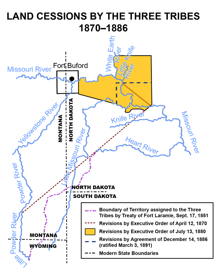
Map shows land cessions and present boundaries of the Fort Berthold Reservation. Adapted from Royce 1977. (SHSND-ND Studies). |
Land Base
The traditional territorial lands of the Mandan, Hidatsa, and Arikara encompassed an area of more than 12 million acres extending from east of the Missouri River to Montana and south as far as present day Nebraska and Wyoming. The Fort Laramie Treaty of 1851 and subsequent executive orders and congressional acts between 1851 and 1910 reduced the original size of the reservation from roughly 12 million acres to 500,000 acres of Indian-owned land.
Land Status
The Fort Berthold Reservation is situated in western North Dakota. The reservation occupies sections of six counties: Mountrail, McLean, Dunn, McKenzie, Mercer, and Ward. The total area within the boundaries of the reservation is nearly one million acres, of which about 50 percent is trust land. Lake Sakakawea covers nearly 155,000 acres of reservation land and about 600 miles of reservation shoreline. Currently, the reservation acreage is more than 988,000 acres of which 378,604 acres are individually allotted, 353,790 acres are in the returned homestead area, and 152,300 acres are in the reservoir taking area. (North Dakota Blue Book)
| Allotted Land |
378,604 |
| Tribal Land |
79,233 |
| Government Owned |
3,280 |
| Private Land |
526,883 |
| *Total Acreage |
988,000 |
*Includes approximately 152,300 acres that resulted from the creation of Lake Sakakawea.
*Includes returned homestead land, 353,790 acres.
Topography and Climate
The Fort Berthold Reservation is situated on the western edge of the Missouri Coteau (Hills of the Missouri). Glaciers formed the topography of this area late in the Cretaceous Period. Erosion further shaped the area. The Missouri Coteau and the Coteau Slope separate the central lowlands of North Dakota on the east, from the Great Plains, on the west. The eastern portions of the Fort Berthold Reservation resemble the Great Plains and are characterized by small rolling hills and valleys. The south and western portions of the reservation are comprised of rolling uplands, large hills and valleys, buttes, and badlands.
The Mandan, Hidatsa, and Arikara settled and farmed along the river bottom of the Missouri River for centuries. The river’s bottomlands afforded them with ideal spots for home sites. In the summer, they built their lodges near the river and planted their crops on the floodplains accessible to water to sustain their large crops. In the winter, they lived under bluffs that provided protection from depredations, and from the elements. The centuries of existence in the bottomlands, with its rich and fertile soil, allowed the Mandan, Hidatsa, and Sahnish time to develop many hybrid forms of beans, corn, squash, and sunflowers. The area was also abundant in chert, a pure and extremely hard, micro-crystalline quartz. Another variety of chert, called Knife River Flint, was used extensively by the ancestors of the Mandan, Hidatsa, and Arikara as a raw material for tools. The term “Knife River” is an English translation of the Hidatsa name, Metsi Ashi which was given because flint for knives was quarried along the river. (Hidatsa Curriculum Review Committee, 1999)
Annual precipitation ranges from 14–16 inches. The average number of growing days is 110–119 with approximately 130–139 days of 28 degrees and above temperatures. (U.S. Department of Interior 1971, p. 117, Schneider p. 142)
Population
The Fort Berthold Reservation is divided into six political districts, or segments: Four Bears (tribal government center), Mandaree, Shell Creek (New Town), Lucky Mound (Parshall), Twin Buttes, and White Shield. These segments represent the major settlements of the reservation.
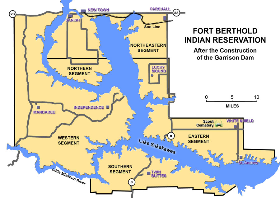
The flooding of the bottomlands of the Missouri River destroyed the long-established Indian population centers of the Fort Berthold Reservation. Before the United States built the reservoir, 289 out of 357 households were living in the reservoir area. The construction of the Garrison Dam and the creation of Lake Sakakawea divided the reservation into five segments. After the original eight communities were moved to the uplands, families were relocated throughout the reservation. Currently, some of the people live in the communities and surrounding areas of Mandaree, White Shield, Twin Buttes, and Four Bears. The current resident population of the Fort Berthold Reservation is 6,341, with an enrolled population of 12,204.
| Population—Fort Berthold Reservation | |
| Total Resident Population | 6,341 |
| Enrolled Members | 12,204 |
| 2010 Census Data Three Affiliated Tribes Enrollment Office Data |
|
Transportation
The construction of the Garrison Dam and the creation of Lake Sakakawea drastically altered the original transportation system of the reservation. After construction of the dam, the government flooded 80 percent of the road system. It was necessary to build 230 miles of new highways at a cost of $3.2 million. The project was completed in the fall of 1954. (Shane, p. 24)

communities established after construction of Garrison Dam. Adapted from Royce, 1977.
(SHSND-ND Studies)
Today the people of the Fort Berthold Reservation have access to three major highways and the Interstate system. Highway 1804, the historic route of Lewis and Clark, borders the east river bank of the Missouri River. Its counterpart, Highway 1806, follows Highway 22 on the western border of the Fort Berthold Reservation. This highway along with Highway 200, serve as the main transportation routes for the communities of Mandaree, Killdeer, and Twin Buttes. The main northern transportation connection point between the eastern and western portions of the reservation is the Four Bears Bridge located west of New Town, North Dakota. The United States Army Corps of Engineers moved the Four Bears Bridge from Elbowoods after the construction of the Garrison Dam. To reach the southern portion of the reservation, residents sometimes have to drive a distance of about 100 miles to reach outlying communities. Original plans to construct a bridge on the southern part of the reservoir were tabled in favor of seeking support for replacement of the antiquated and narrow Four Bears Bridge. The replacement of the Four Bears Bridge was approved in the year 2000 and completed in 2005.
Labor Force
According to the 2000 U.S. Census, North Dakota counties that include Indian reservations are among the few areas of the state to experience population increases. Normally, the age distribution of a population is important when determining the labor supply in the area. Age distributions generally do not change significantly in the short-term unless large population changes have occurred in the area. With the growth of economic activity generated by the establishment of casinos and other economic ventures associated with industry and business, population statistics show steady increases as Indian people return home.
Infrastructure and Services
The tribal headquarters of the Three Affiliated Tribes was built in 1979 and is located four miles west of New Town on state Highway 23. The main communities on the reservation are experiencing growth in the commercial, industrial, and business sectors. The government sector, consisting of the Bureau of Indian Affairs, administration of the Three Affiliated Tribes and its enterprises and Indian Health Services, is still the major employer on the reservation. Residents travel to Bismarck, Dickinson, Minot or Williston for wholesale shopping. Railroad, commercial, and charter air transportation services are available in Minot and Bismarck, North Dakota. New Town and Parshall have landing strips for smaller aircraft.
Tribal Administration Programs
Tribal Employment Rights Office (TERO)
The Tribal Employment Rights Office was founded and based on the results of laws that allowed Indian preference in employment and contracting. These laws, in effect since the early 1960s, were poorly enforced. The Three Affiliated Tribes established a Tribal Employment Rights Office (TERO) in 1977 to ensure equal opportunity in the employment of tribal members. In addition, the tribe also passed a tribal employment ordinance. With increased economic activity caused by the oil boom of the 1980s, the ordinance was revised to ensure Indian contractors were afforded opportunities in the oil industry.
Environmental Division
The Three Affiliated Tribes was one of the first tribes in the nation to start an Environmental Division of its tribal administration. In 1981, the tribe authorized an air-monitoring program. Since that time, the Environmental Division has grown to encompass a variety of programs.
Child Care
The Casey Family Foundation, a nationwide nonprofit foster-care organization committed its resources to the welfare of Indian children. On the Fort Berthold Reservation, this foundation has provided financing to the Three Affiliated Tribes for the establishment of a day-care facility. This facility provides services primarily to the children of working parents and single parents who are furthering their education. The Tribal Business Council adopted North Dakota’s child care rules and regulations, and all employees must qualify under a program that certifies training in CPR, first aid, health, safety and sanitation procedures, nutrition, socialization, and early childhood development.
Housing
One of the greatest needs on the reservation is the need for housing. The Fort Berthold Housing Authority was established in 1968. Under its administration, 457 mutual self-help and low-rent housing units are maintained. The Fort Berthold Housing Authority is one of 180 such programs situated throughout Indian Country.
Drug Elimination Program
The Three Affiliated Tribes, with the Fort Berthold Housing Authority, currently operates a drug elimination and youth sports program, and a cultural program. Program funds provide facilities that offer alternative activities for youth throughout the year and serves as an outreach resource to all Fort Berthold communities.
Buffalo Project
The Fort Berthold buffalo herd of 350 roam freely on a 13,000 acre preserve near Mandaree, North Dakota. Considerable work went into this project to assure its independent operation. Each year the Tribe donates buffalo meat for ceremonial purposes, community functions, ceremonies, and celebrations.
Business Sector
Four Bears Casino and Lodge
The Four Bears Casino and Lodge was opened to the public on July 16, 1993. Located in the Four Bears community four miles west of New Town, North Dakota, the facility was constructed on the site of the original Four Bears Lodge, built in 1972. The facility offers a 96-room motel, a full service restaurant, a gift shop, and a high stakes gaming facility, including bingo.
The Three Affiliated Tribes operates and maintains the gaming facility. The Casino and Lodge employ more than 322 individuals, and about 79 percent of those are tribal members.
Four Bears Convenience Store and Gas Station
A 24-hour convenience store and gas station was opened in 1993. This facility, placed next to the Casino and Lodge, provides a convenient stop for tourists and visitors to the area.
Four Bears Recreation Park
The Four Bears Recreation Park is located on the shoreline of Lake Sakakawea and adjacent to the Four Bears Lodge and Casino. The Park features 85 sites, twenty-five of which are full-service featuring electrical hookups, water, sewer facilities, laundry and shower facilities, and twenty-four primitive sites. Future development is planned.
The Three Affiliated Tribes Museum
The Three Affiliated Tribes Museum was built in 1964 with funds from the Economic Development Administration, the Tribe, and funds from a trust fund established by an Arikara tribal member, Helen Gough of White Shield. A board of directors governs the museum and is responsible for maintaining the museum’s collections and exhibits. The museum is open from April through November.
Fort Berthold Community College
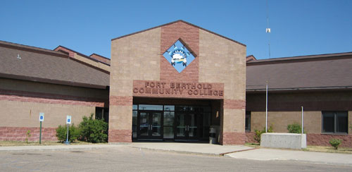
The Fort Berthold Community College was established in New Town in 1973, and chartered in 1974. A seven-member board of directors oversees the operation of the college. From 1973 to 1992 the college existed in makeshift facilities. A modern centralized facility was built in New Town in 1992 offering administrative offices, classrooms, vocational and technical labs, a lecture room, and a student union. Classrooms and a library were added later. In 1997, new classrooms, a science lab, and an expanded parking lot were added.

for the college was constructed at New Town in 1992. (Photo by Neil Howe)
Fort Berthold Community College, by nature of its charter, serves the community. Satellite sites have been established in the communities of Twin Buttes, Mandaree, and White Shield. Enrollment averages 270 students per semester, 80 percent of whom are Native American. Land Grant Institution *status was granted in 1984. The North Central Association of Schools and Colleges granted the college accreditation in February of 1988. In 1996, the college was accredited for an additional ten years. Fort Berthold Community College is a member of the American Indian Higher Education Consortium (AIHEC), a consortium of 46 Indian-controlled community colleges located across the United States. (TAT OIEP Report, 1996)
Dialysis Center
The Three Affiliated Tribes Dialysis Center, located in the Four Bears Community, offers medical care for dialysis patients throughout the reservation. Patients are transported for treatment. This facility is the first of this kind to receive federal funding to develop medical care focused on unique health needs and care for diabetic patients. This is the first facility of its kind to receive state and federal funds and is developed as a state licensed diabetic. Prior to this time, patients had to be transported several hours to major cities for treatment.
Industrial Sector
Northrop Corporation
Northrop Manufacturing is located on the eastern edge of the city of New Town, North Dakota. The facility manufactures and develops air frames, missiles, and electronic systems for the Stealth Bomber, and receives contracts from the Department of Defense, National Aeronautics and Space Administration (NASA), and commercial aviation companies. The plant currently employs 95 people. Tribal members comprise approximately 24 percent of the company’s employees.
Mandaree Electronics Corporation (MEC)
Mandaree Electronics Corporation (MEC) is a tribally chartered corporation established in the Mandaree Community. MEC employs and provides training to tribal members to produce or assemble circuit boards and wire harnesses for the military. Northrop Corporation and Killdeer Manufacturing of North Dakota Corporation provide equipment and technical assistance and training. Individuals trained at this location serve as the labor supply for the Northrop Corporation and Killdeer Manufacturing Companies and other electronics firms.
Footnote
- In 1862, Congress passed the Morrill Act which established the land grant university system. President Abraham Lincoln signed into law what is generally referred to as the Land Grant Act. This legislation granted to each state 30,000 acres of public land for each U.S. Senator and Representative under apportionment based on the 1860 U.S. Census. Proceeds from the sale of these lands were to be invested in a perpetual endowment fund which would provide support for colleges of agriculture and mechanical arts in each of the states.
- In 1994, Congress, under the Improving America’s School Act of 1994, Part C—1994 Institutions created a new section entitled “Equity in Educational Land—Grant Status Act of 1994.” This legislation granted “Land Grant status” to 29 tribally-controlled community colleges nationwide and authorized appropriations to these institutions.