


The second supporting question, “How did early peoples on the northern Great Plains think about where they were located?” helps students use sources to unwrap the context of the time and topic being examined. Complete the following task using library and internet resources to build a context of the time period and topic being examined.
Formative Performance Task 2
Using library and internet research, write a summary of why north is “up.” Is this a universal concept, or have there been other cardinal directions that have served as “up?” How do we know? What else can you find? Create a map of your community using a cardinal direction as “up” besides north. Include a symbol key.
Featured Sources 2
Study Featured Sources A-B that depict Native American maps that are not oriented north. Students will also conduct their own research through the library and internet sources.
| Source A |
Ac ko mok ki’s Map 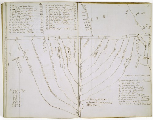
|
| Source B |
Wind, Dakota. “Makhoche Waste: The Beautiful County, A Lakhota Landscape Map.” The First Scout (blog). n.d. http://thefirstscout.blogspot.com/p/a.html. |