


When North Dakota became a state in 1889, it took on the shape we are familiar with today. The state is roughly a rectangle with a little push outward in the southeast corner. (See Image 1)
However, this place on the northern Great Plains was not always named North Dakota, and its boundaries were unclear.
In the middle of the 18th century, the land that is now part of North Dakota was claimed by France, then Spain, then France again. Another part of North Dakota was claimed by Great Britain.
When the United States bought the land known as Louisiana from France in 1803, that piece of land was defined as the drainage of the Missouri River. Drainage refers to the river and its tributaries. Louisiana included what is now western North Dakota, but did not include anything east of the coteau (central) region. The eastern portion drained into the Red River or its tributaries. Those rivers ran north to Hudson Bay, so it is a different drainage system than the Missouri River.
Once the boundary between the United States and Canada was set at the 49th parallel by the Treaty of Peace (1818), all of the land which is now North Dakota became part of the United States.
As our nation expanded, however, the eastern and western parts of North Dakota (usually divided at the Missouri River) were in different territories. At different times, parts of North Dakota have been included in the territories of Michigan, Wisconsin, Iowa, Minnesota, and Nebraska. The name changed, too. The fur traders called this region the Upper Missouri Country. Minnesota referred to the region as Pembina (or sometimes Pambian).
When Dakota Territory was created in 1861, the territory included today’s South Dakota as well as parts of Montana and Wyoming (See Map 2). In 1863, Congress reduced the size of DakotaTerritory. The removed areas became part of Montana and Wyoming. (See Map 3)
The territory was divided into two states, North Dakota and South Dakota, in 1889. (See Map 4)
The lines drawn by Congress or by international treaty are called political boundaries. In the 18th and early 19th century, the political boundaries often matched a geographical boundary such as the Missouri River or the Red River. When Congress created the territory, however, the political boundaries were drawn according to measurements determined in Washington, D.C.
The final boundaries of North Dakota were established by surveyors and construction crews. The boundary line on each side of the state has its own story.
Why is this important? The lines of the territory which became our state were arbitrarily (meaning without particular reason) drawn and re-drawn as suited the members of Congress. The lines were meaningless to American Indians living on the northern Great Plains. American citizens, however, who slowly moved into the area around Yankton and Pembina were eager to have a government structure so they could establish businesses, schools, and roads and elect a representative to Congress. When the area was a distant part of Minnesota Territory, residents had little hope of having the government they needed.
Though the lines are invisible, they are important as a foundation of government. People need to know what township and county they live in so they can vote, pay taxes, attend school, and seek justice in the proper district.
East and West Boundaries
The eastern boundary of North Dakota is 434 miles long if you follow the geographical boundary of the Red River of the North. The river has many turns and twists, sometimes nearly doubling back on itself (See Image 2).
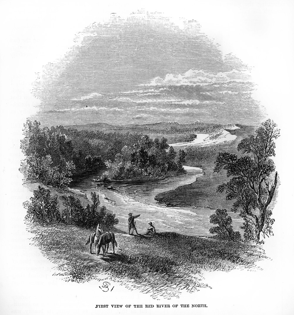
The legal boundary, which runs down the center of the Red River, is more than twice the length of the boundary measured "as the crow flies." If you were to drive north from the southern border to the International Boundary without any detours, the distance would be 213 miles.
When Minnesota became a state in 1858, its western boundary was defined as the middle of the channel of the Red River of the North from the 49th parallel (the Canadian border) to the middle of the Bois de Sioux River channel to Lake Traverse. When North Dakota became a state, the boundary law stated that the line would run along the middle of the Red River channel from the 49th parallel along the boundary line of the state of Minnesota to a "point where the seventh standard parallel intersects the same." The "same" referred to the Red River. Someone forgot that the Red River is formed where the Ottertail River (from Minnesota) joins the Bois de Sioux River. That point is nearly 25 miles north of the seventh standard parallel.
Fortunately, the extreme southeast corner of the state was saved by the phrase "along the boundary line of the State of Minnesota."
The western boundary was somewhat less complicated. The story of the boundary starts back in 1850 when all measurements of longitude across the United States were based on a line that ran through the middle of the Naval Observatory in Washington, D.C. That measurement set the western boundary of North Dakota at 77003’02.3". This line is the 27th meridian west of Washington, D.C. Today, using Greenwich, England as the starting point, the line is at 104003’02.3".
The western boundary is 210.95 miles long. Surveyors marked the boundary with stone or cottonwood markers at one mile intervals. Though the western boundary line was supposed to be a simple north-south line, it is just a little off. Nineteenth century surveying tools were a little less accurate than the tools available today. The line is 533 feet farther west at the Canadian border where the line is measured at 104002’54".
Southern Boundary
The southern boundary of North Dakota divided Dakota Territory into two states: North Dakota and South Dakota. The southern boundary is 361.57 miles long. Charles Bates of Yankton surveyed the line along the seventh standard parallel in 1891.
Establishing the southern boundary of North Dakota was far more complicated than the east or west boundaries of the state. Congress had wanted to set the line at the 46th parallel of north latitude. However, when Dakota Territory residents met to discuss a possible division of the territory in 1880, they found a problem. If the boundary was on the 46th parallel, several townships in the southern part of Emmons, Logan, LaMoure, Ransom, and Richland counties would end up in South Dakota. Some homesteaders would find that their farms straddled the line between two states. The Omnibus bill of 1889 granting statehood to North and South Dakota took this problem into account. The line was to be placed on the seventh standard parallel.
The standard parallels are imaginary lines parallel to the equator, much like lines of latitude. However, the standard parallels were measured from a different starting point than latitude. Surveyors used the standard parallels to mark township lines. Every fourth township line (those running east and west) was a standard parallel. These lines are 24 miles apart.
Because the seventh parallel corresponded to township and section lines, it should have been a good solution to the problem faced by the citizens of Dakota Territory. However, in 1889, there were two seventh standard parallels accepted by the Department of the Interior. One was created in error by the surveyor general of Minnesota.
The people of North Dakota and South Dakota had to agree on which parallel to use before they could establish the boundary line. The states held conventions to discuss their constitutions and other statehood issues. When the boundary line was discussed, South Dakota decided that it did not have the authority to make the decision. It seemed to be an interstate, therefore federal, issue. North Dakota also said it was a federal matter.
Members of Congress saw the problem differently. Many believed that Congress should not pay for a survey because the boundary was a state problem and responsibility. Finally, in September, 1890, Congress agreed that the federal government had an interest in knowing exactly where the seventh standard parallel was located. Congress passed bill appropriating the money for the survey.
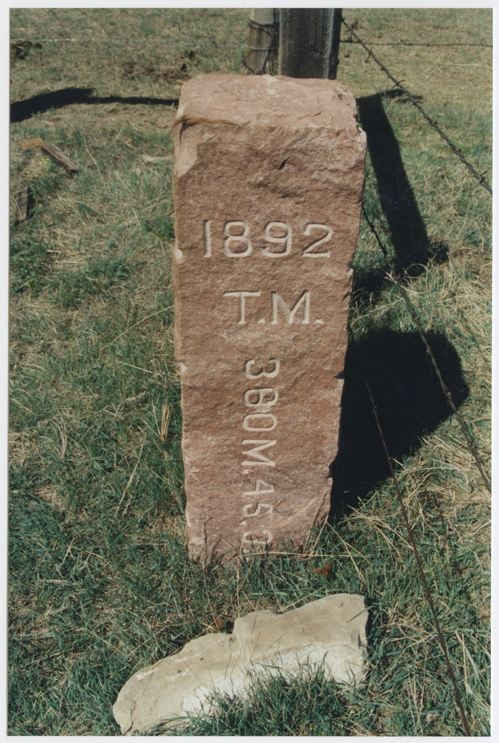
The southern boundary of North Dakota followed county lines. The counties had been surveyed as far west as the Missouri River several years earlier. The survey had to find the line from the Missouri River to the Montana border. Charles Bates conducted the survey of the border in 1891 and 1892. He placed quartzite markers at ½ mile intervals along the boundary.
The markers were 7 feet tall and 10 inches square. The north side has "N.D." engraved in the stone. "S.D." is engraved on the south side of the markers. (See Image 3)
Like the east and west boundaries, the survey of the southern boundary had some errors. At the Montana border, the line is 36 seconds off. The southwest corner of North Dakota is 3,660 feet farther north than the southeast corner.
The International Boundary
The International Boundary is the northern border of North Dakota. This line divides North Dakota and the United States from Canada. The line is on the 49th parallel which was determined by the Treaty of Peace of 1818. The 49th parallel was acceptable to both Great Britain (which ruled Canada at the time) and the United States.
The survey to locate this line was conducted in 1874 and 1875. There were two surveying parties: one was British and the other was American. Using equipment that was up-to-date for the time, but not as accurate as modern equipment, the surveyors marked the line with monuments.
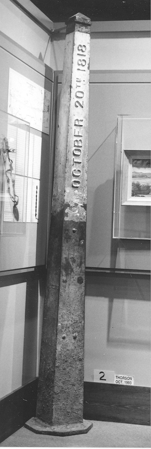
The monuments were heavy cast iron posts that weighed 285 pounds. The posts were hollow and were set on a cedar post that was pounded into the ground. The iron post had words cast into both sides that read: "Convention of London, October 20, 1818." (See Image 4) Where it was not possible to place iron marker posts, the surveyors built stone and earth cairns. These are simple mounds that stand above the soil to mark the location of the line.
By 1900 the earth and rock cairns had nearly disappeared due to rain, snow, and frost. The iron markers still stood in many places, but some had been damaged, and others stolen. In 1908, both the United States and Canada agreed to survey the border line again.
The 1908 survey crews found many of the original markers in the correct spot. The old iron markers had to be removed and then re-set in cement. The center of the marker was to be exactly on the line.
New markers were established where there was no marker. It took more than five years to complete the survey from the Rocky Mountains to the Lake of the Woods (in northern Minnesota). The men who worked on these crews lived in tent camps and moved often. They drank slough water and had permission to shoot cattle they found along the border for their meals.
The survey crew had to clear trees from the borderline in the Turtle Mountains. They had to have a clear line of sight from one surveying point to the next. The path through the Turtle Mountains was cut 100 feet wide at the ground so the line of sight would be 20 feet wide at the top of the trees.
The other challenge the survey crew faced was to make the borderline conform to the gentle curve of the earth. Surveyors can only work with straight lines. They first had to figure the straight line, then adjust it by 2 or 3 inches to place the markers in the exact place on the 49th parallel. The line had to be correct, even if it ran through the middle of a town or a farm.
Today, the clearing through the trees is still maintained and the markers remain in place.
Document 1. The International Boundary – The Pembina Memorial
The question of the international boundary line was settled when diplomats of the United States and Great Britain signed the Treaty of Peace of 1818. However, people living along the border, especially at Pembina, still had trouble with Hudson’s Bay Company hunters coming into their territory. They also had questions about exactly where the line was located. They had trouble establishing title to property without a secure border.
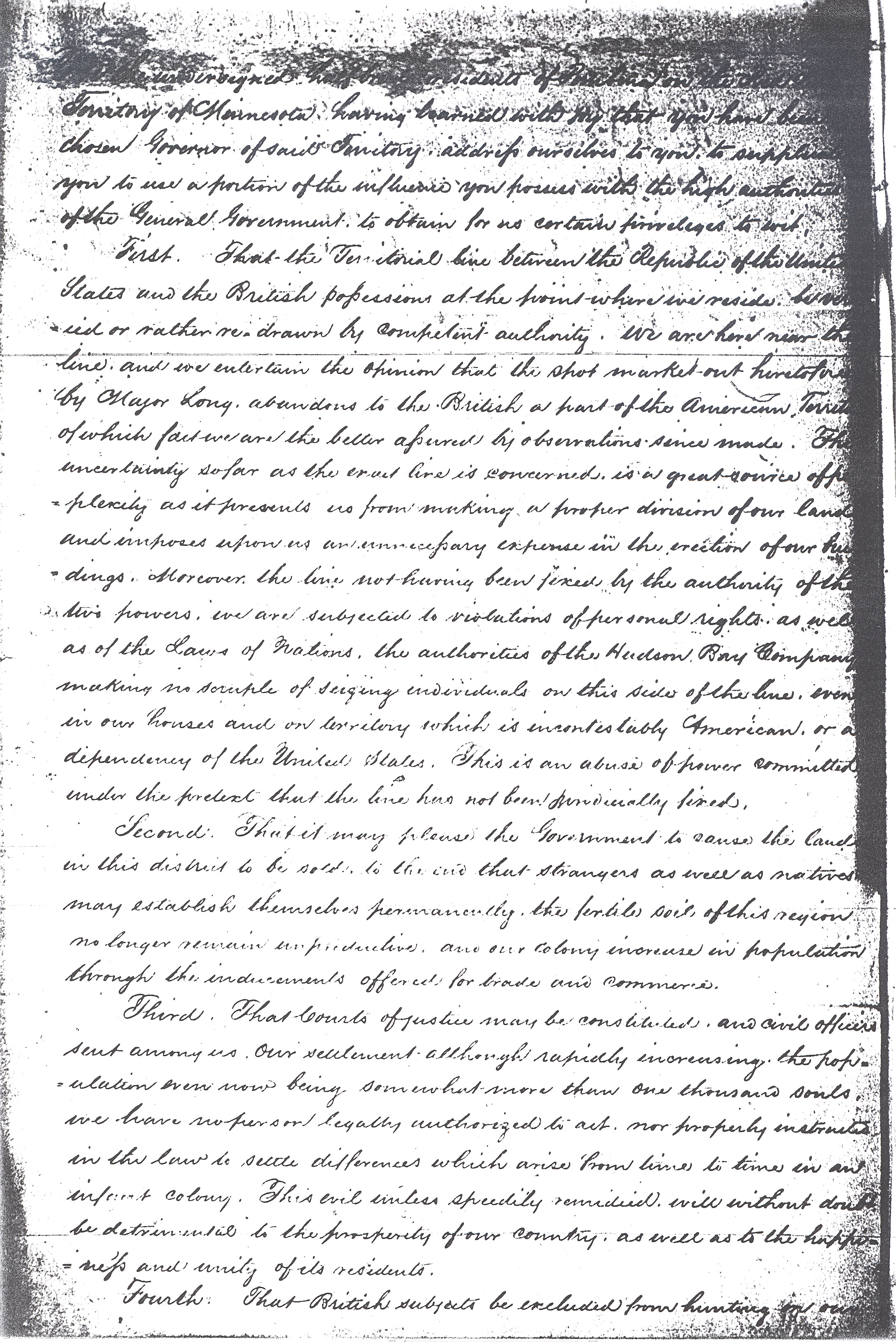
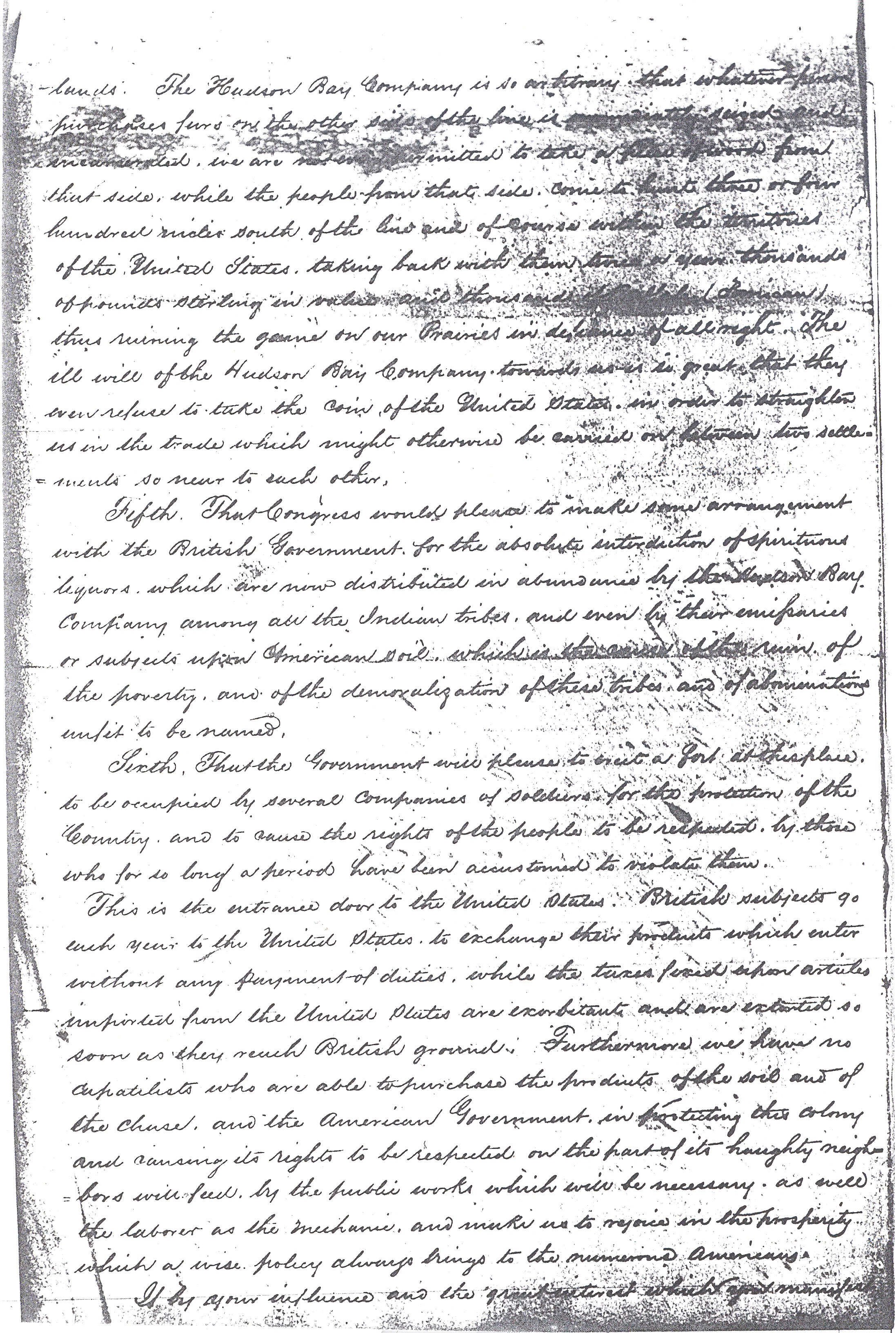
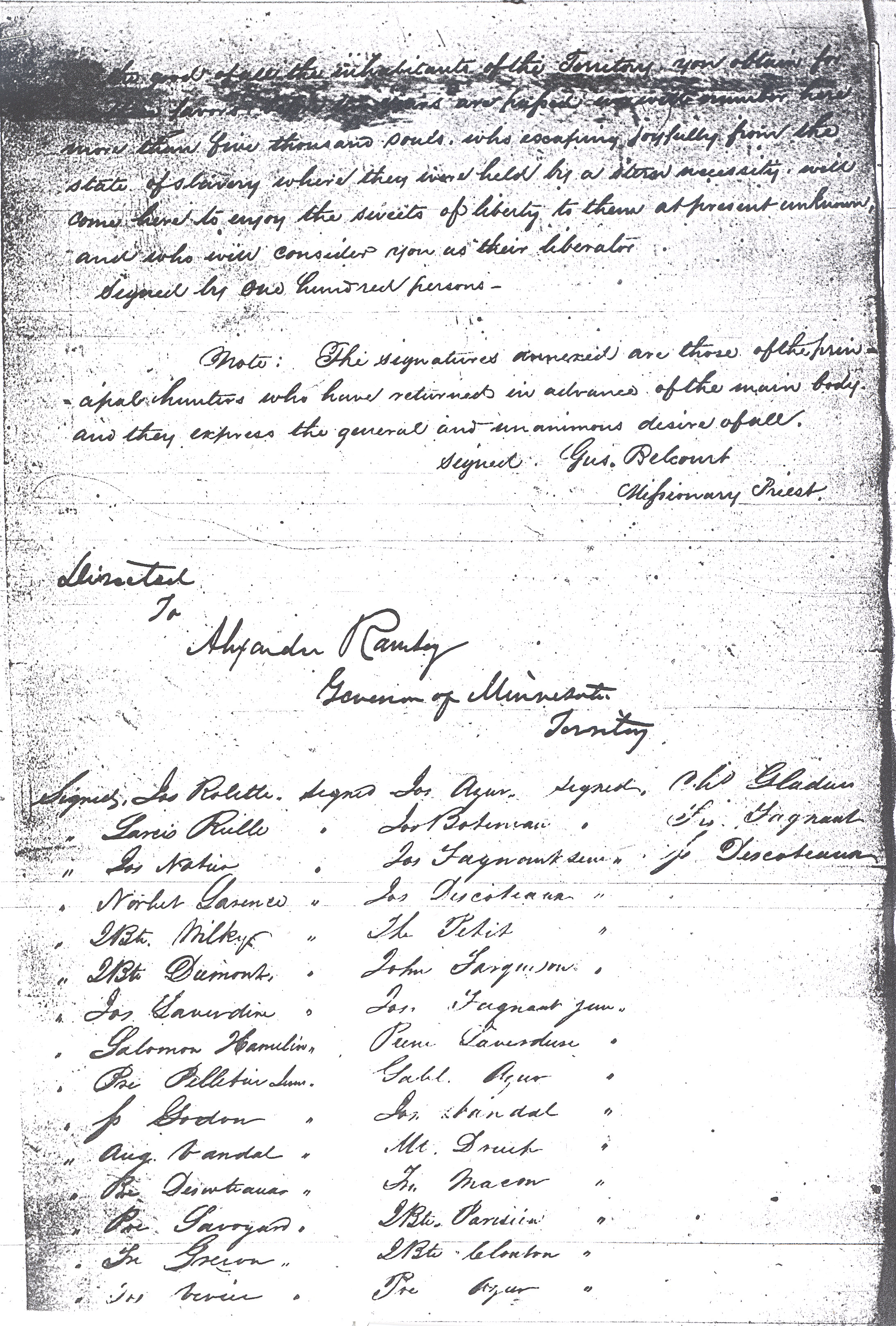


Many of the residents of Pembina were the Metís descendants of French or Scottish fur traders and Chippewa women. One-hundred six men signed a Memorial to Congress asking for a better definition of the border line in 1849. They also wanted legal protection against the British and employees of the Hudson’s Bay Company. They argued that the original survey of the border by Major Stephen Long in 1821 was inaccurately placed a couple of miles south of the true border line. A portion of the memorial has been transcribed for you to read. The entire document in its original script of the translation is attached, though it is very difficult to read. The first to sign the memorial was Joseph Rolette.
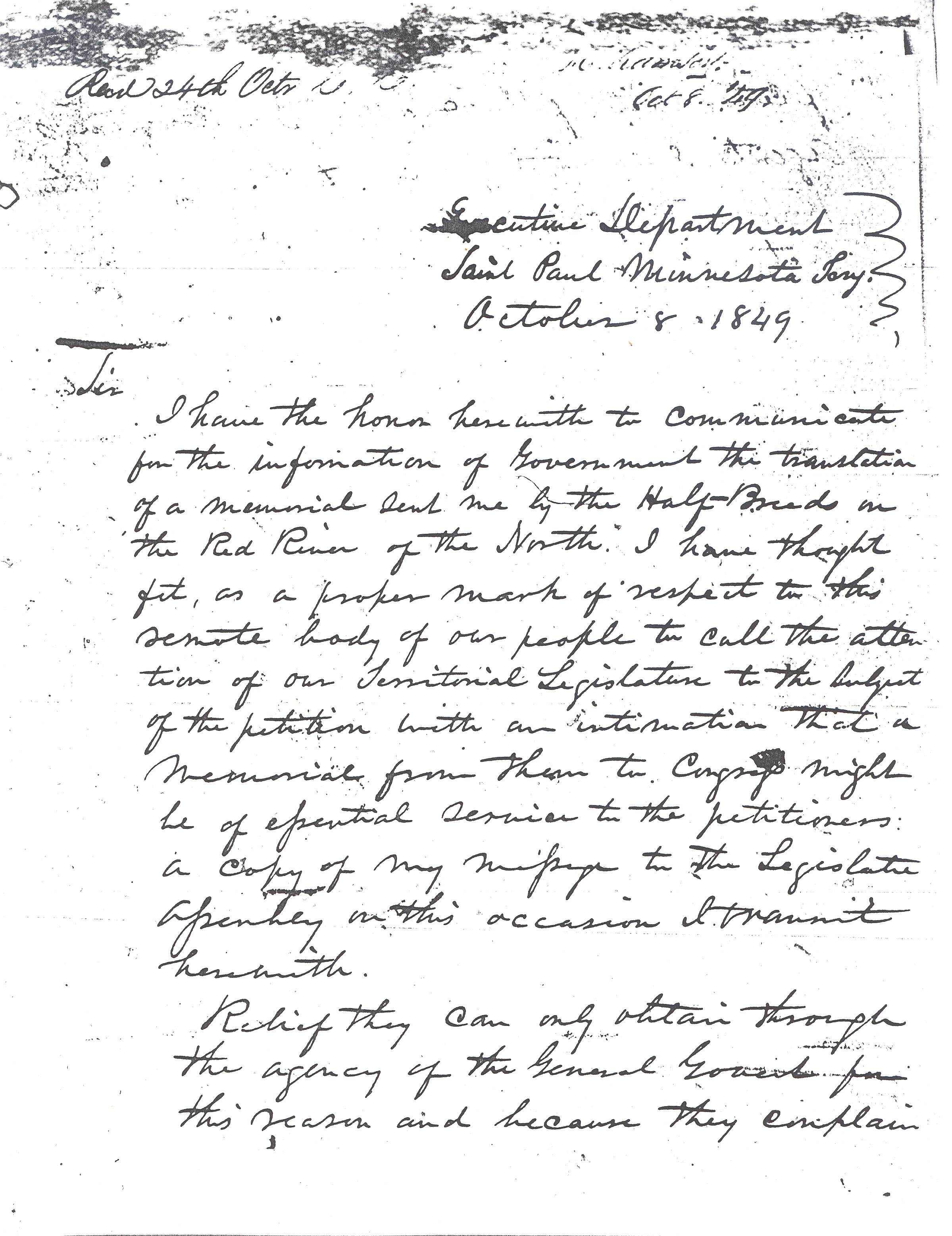
The second document is a letter from the governor of Minnesota Territory to the United States Secretary of State informing him that the Memorial from the residents of Pembina is on its way and that he has had the memorial translated from the original French version. Governor Ramsey refers to the people of Pembina as "Half-Breeds." Today, the word "half-breed" is unacceptable so we use the term "Metís." In 1849, half-breed was not necessarily a derogatory term and Governor Ramsey shows his respect for the leading men of Pembina who want to establish their town and their homes within the boundaries of the United States.
Document 1 Transcription
Memorial to Congress from Pembina (transcribed excerpt).
"having learned... that you have been chosen Governor of [Minnesota] Territory, [we] address ourselves to you, to supplicate you to use a portion of the influence you possess with the high authorities of the General Government to obtain for us certain privileges to wit,
First. That the Territorial line between the Republic of the United States and the British possessions [today’s Canada] at the point where we reside be verified or rather re-drawn by competent authority. We are here near the line and we entertain the opinion that the spot marked out heretofore by Major Long, abandons to the British a part of the American Territory of which fact we are the better assured by observations since made. The uncertainty so far as the exact line is concerned is a great source of perplexity as it prevents us from making a proper division of our land and imposes upon us an unnecessary expense in the erection of our buildings. Moreover, the line not having been fixed by the authority of the two powers, we are subjected to violations of personal rights as well as of the Law of Nations, the authorities of the Hudson Bay Company making no scruple of seizing individuals on this side of the line even in our houses and on territory which is incontestably American, or a dependency of the United States. This is an abuse of power committed under the pretext that the line has not been periodically fixed.
Second. That it may please the Government to cause the land in this district to be sold to the end that strangers as well as natives may establish themselves permanently, the fertile soil of this region no longer remain unproductive, and our colony increase in population through the inducements offered for trade and commerce..."
Governor Ramsey’s Letter.
Executive Department
Saint Paul Minnesota Territory
October 8 1849
Sir
I have the honor herewith to communicate for the information of Government the translation of a memorial sent me by the Half-Breeds on the Red River of the North. I have thought fit, as a proper mark of respect to this remote body of our people to call the attention of our Territorial Legislature to the subject of the petition with an intimation that a memorial from them to Congress might be of essential service to the petitioners. A copy of my message to the Legislative Assembly on this occasion I transmit herewith.
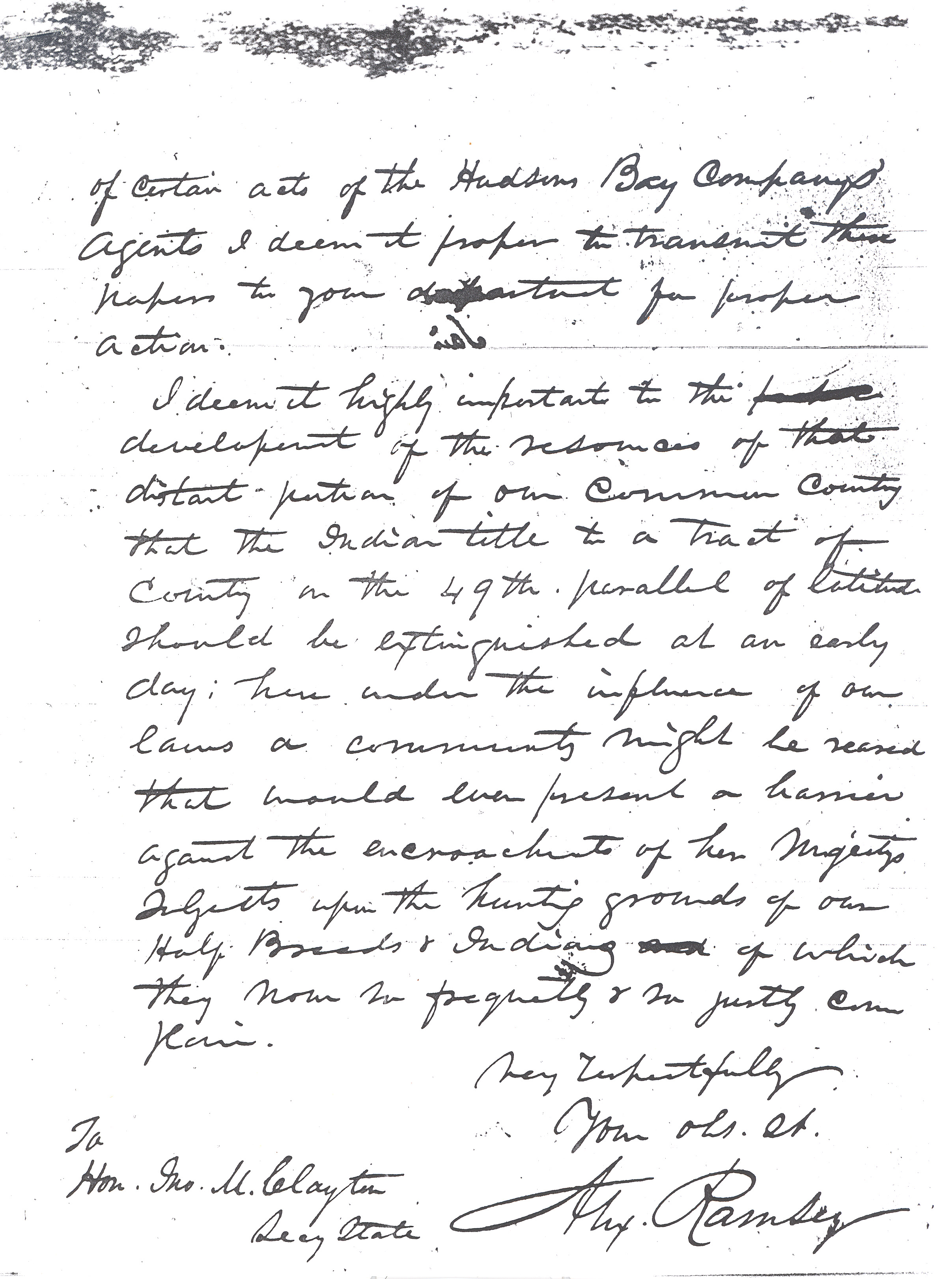
Relief they can only obtain through the agency of the General Government for this reason and because they complain of certain acts of the Hudsons Bay Companys’ agents I deem it proper to transmit these papers to your department for proper action.
I deem it highly important to the development of the resources of that distant portion of our common country that the Indian title to a tract of country in the 49th parallel of latitude should be extinguished at an early day: here under the influence of our laws a community might be raised [?] that would ever present a barrier against the encroachment of her Majestys’ subject upon the hunting grounds of our Half-Breeds and Indians of which they now so frequently and so justly complain.
Very Respectfully
Your [obedient servant]
Alex Ramsey
To
Hon. Jno. M. Clayton
Secy State
SHSND, James Taylor Papers Mss 20187.