


There are more than 500 federally recognized tribal nations within the United States. There are more than 200 tribes without federal recognition that are recognized by state governments or who are petitioning for federal recognition. Each of these tribes has its own history, language, and culture. There are five federally recognized tribes in North Dakota, four reservations, and one service area. Federally recognized tribes have sovereign status and make their own laws. Treaty-making in the 19th century was based on the Doctrine of Discovery. As the concept of Manifest Destiny evolved, it impacted and accelerated European and American treaty making with tribal nations and pushed land claims that often led to conflict and removal of Native American people from traditional lands. By the 1700s the push west for land impacted tribes living on the northern great plains. This led to the establishment of reservation lands and modern tribal governments. Have students work in groups to complete the following activity. Using maps and websites, identify traditional homelands and compare them to modern reservations. Facilitate a class discussion about what students learned. Did their research support or contradict what they thought they knew? What surprised them the most?
Activity: Chippewa and Metis Homelands
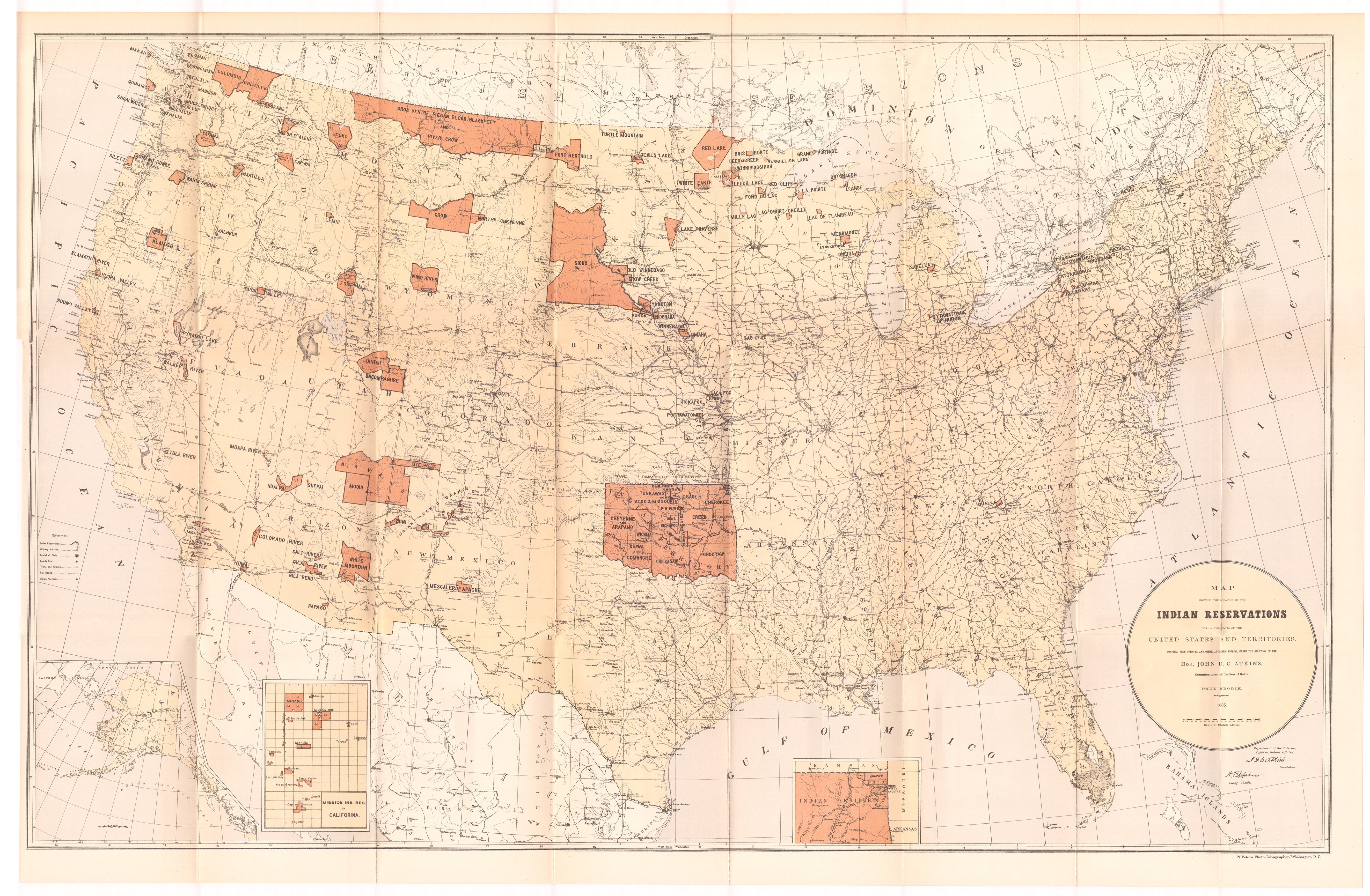
Compare the following four maps: Traditional Native Lands, the 1885 Paul Brodie map of Indian Reservations, the Ossiniboia Territory map from 1814, and a contemporary map of North Dakota.
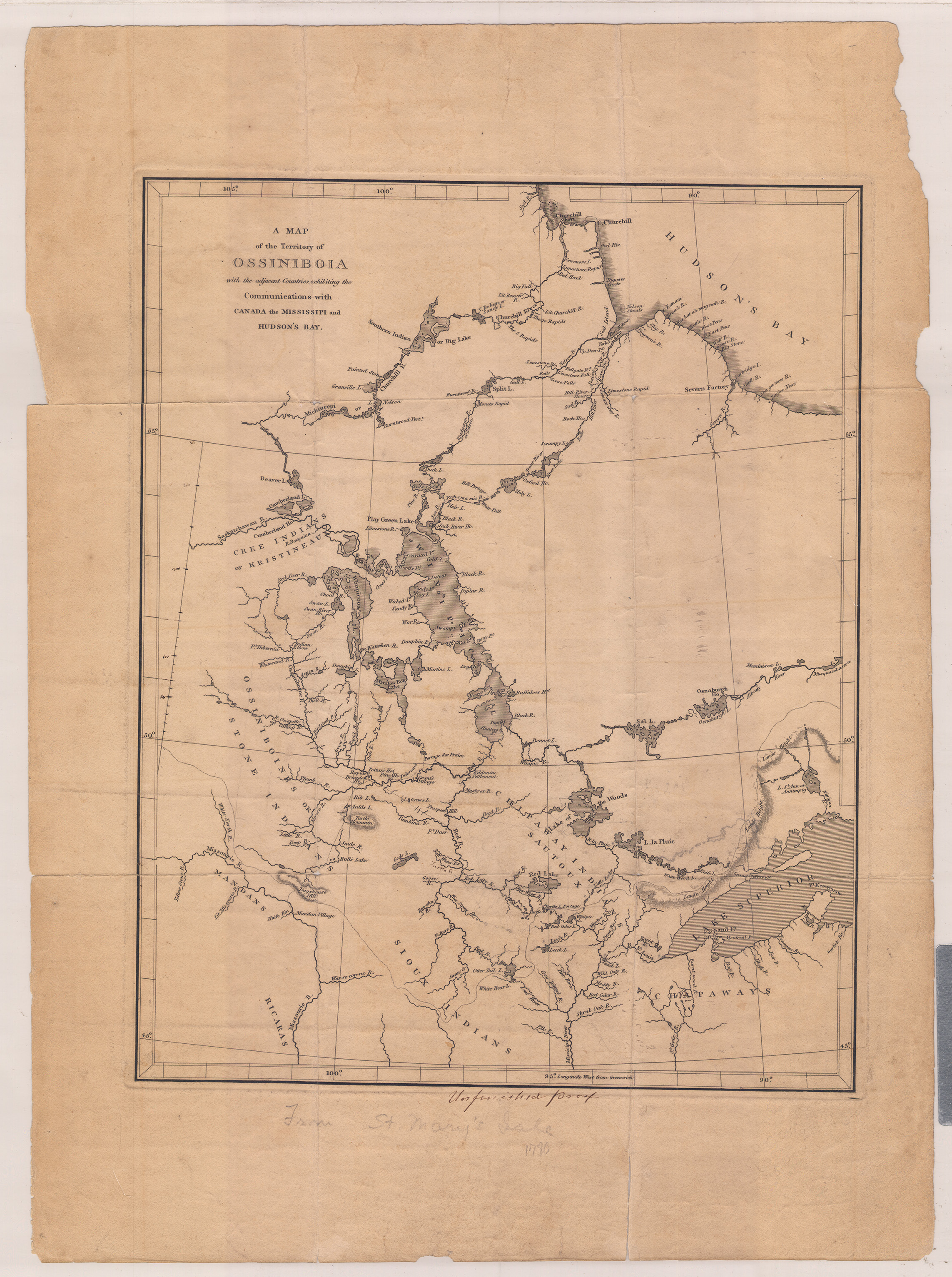
The Map of the Territory of Ossiniboia was drawn around 1814 by an unknown cartographer or mapmaker. It measures 19 7/8 inches by 14 ½ inches. It shows the Canadian perspective of the northern Great Plains. While its central focus is the area which is today known as Manitoba and Saskatchewan, geographic features of modern-day North Dakota are clearly visible including the Red River, the Pembina River, and Devils Lake (Gods Lake). The Louisiana Purchase of 1803 was defined by the Missouri River drainage or watershed which did not include the north flowing Red River and its tributaries. Canada claimed the Red River watershed and all territory not drained by the Missouri River. The two nations agreed on a boundary line at the 49th parallel from the Lake of the Woods to the Rocky Mountains in 1818. The remaining distance was completed by treaty in 1846.
The future state of North Dakota is entirely present in this map, though the course of the Red River is mistakenly drawn as flowing from Ottertail Lake and some other important features are not accurate. Some features, such as Warreconne River (Beaver Creek) indicate that the mapmaker was familiar with the maps of Lewis and Clark. Of great importance are the faint lines that indicate commonly used trails for commerce between the Mandan Villages and the Hudson’s Bay Company trading post at Brandon House. Can you identify the locations of the modern towns of Grand Forks, Caledonia, Pembina, and Williston? Do the commerce trails follow any present-day highways?
What information do these different maps depict? How has the land available to the Chippewa changed over time? Were the lands of the Chippewa included in the Louisiana Purchase? What is the Trenton Service Area? Share back to the whole class what your group has learned, and then, as a class, compare and contrast the data.
Learn more about the history and culture of Native Americans through one of these additional resources:
- North Dakota Heritage Center & State Museum and state historic sites.
- Teachings of Our Elders—The North Dakota Native American Essential Understandings
- National Museum of the American Indian—a Smithsonian Museum.
- Treuer, Anton. Everything You Wanted to Know About Indians But Were Afraid to Ask. St. Paul, MN: Minnesota Historical Society Press, 2012.
- National Museum of the American Indian. Do All Indians Live in Tipis?: Questions and Answers from the National Museum of the American Indian. New York, NY: Smithsonian Institution Press, 2007.
- Each reservation in North Dakota has a college, and most of them have museums, cultural centers, and a tourism division. Follow their social media feeds to learn more about programs, events, and other learning opportunities.