


Missouri Coteau
Eugene Marshall faulted S. M. Rothhammer for not fully describing the Missouri Coteau.Coteau is a French word for a hilly region, especially one that divides two river valleys. Some people simply call this area the continental divide. But historically, explorers and travelers recognized this region in the central part of the state as a unique geological feature. It was created by glaciers during the ice age. There are few rivers or creeks to carry water out of the region, so the water puddles in small seasonal ponds and larger sloughs and lakes. Marshall’s description of the surface characteristics of the coteau is excellent. Rothhammer noted the many hills and ponds, but he thought the water was dammed by beavers. Marshall thought the ponds did not flow into rivers because the “parched condition of the soil. . . ” drained them before they could gather into a stream.
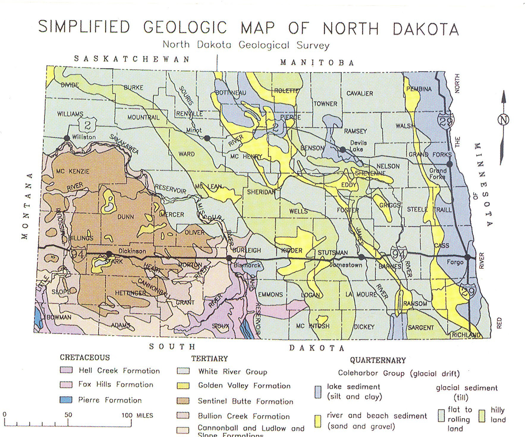
Marshall correctly identified the coteau as the continental divide which sends some of North Dakota’s rivers south to the Mississippi River and the Gulf of Mexico and other rivers north to Hudson Bay. (See Map 2) Marshall wrote that the coteau was “unlike any other in the North West,” but he did not state that the Missouri Coteau extends from Saskatchewan to South Dakota. While Marshall was correct about the geography of the coteau, he did not quite understand the geology of its formation during the Ice Age thousands of years previously.
The coteau was created by the glaciers that moved south from the Arctic into North Dakota (and beyond) beginning about 2 million years ago. The glaciers picked up rocks and soil as they moved along. Where they stopped moving, moraines, or hills of rocky soil and debris, were left behind. Two kinds of moraines form the landscape of the coteau. Terminal moraines are ridges of rock debris (sometimes called “till”) that formed along the edges of the glaciers where they reached their destination before melting. Dead-ice moraines were formed where glaciers stopped during the last period of glaciation, or ice age, about 12,000 years ago. While there are dead ice moraines in the Turtle Mountains and in southern Ransom County near Lidgerwood, most are found in the Missouri Coteau.
The eastern edge of the coteau is called the escarpment, which means slope. The Missouri escarpment can be gently sloping, or quite steep. In some places it rises 650 feet over the course of a mile.
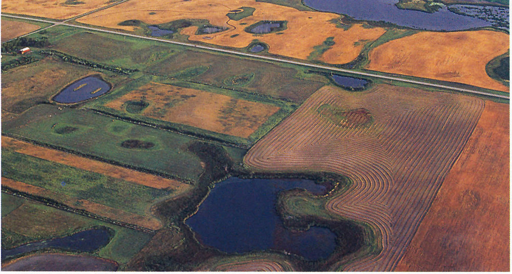
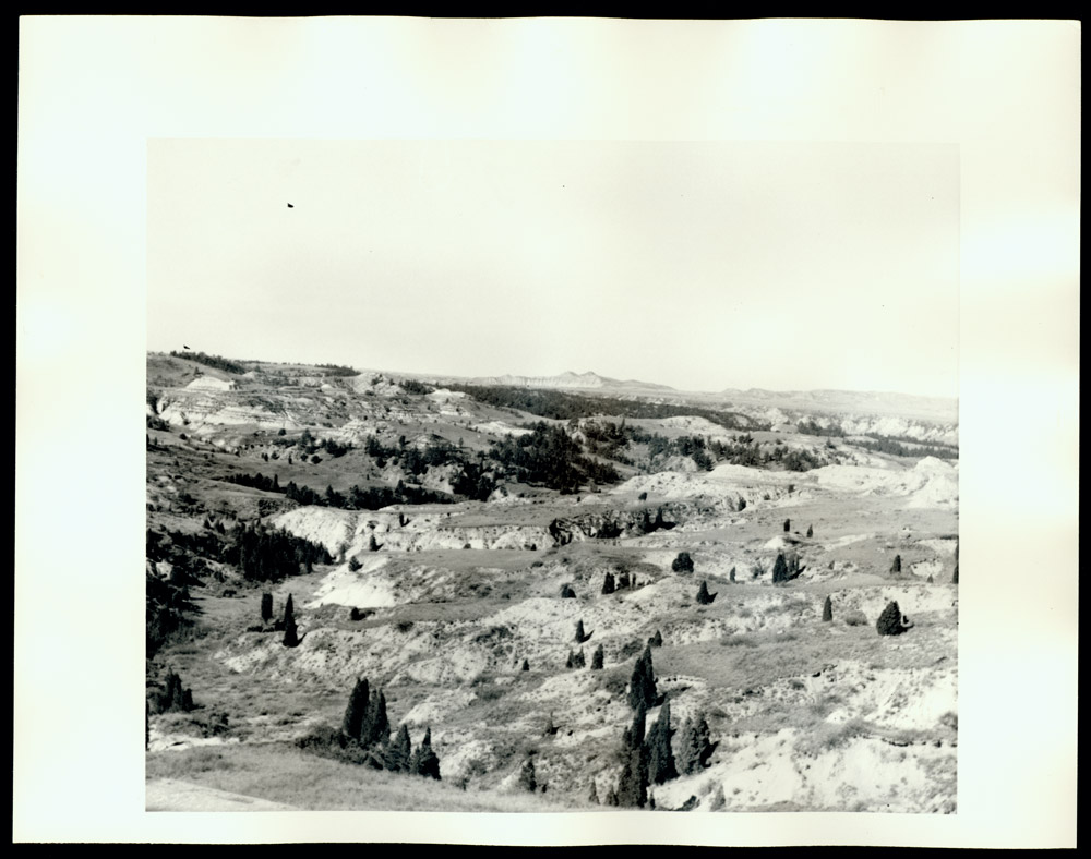
The result of the movement of ice and rock was the creation of a region of small disconnected ponds and rocky soil. (See Image 1) The ponds do not drain into creeks or streams. Often the water becomes alkaline or stagnant.
Why is this important? Rothhammer and Marshall both believed that the grass covering of the coteau would support livestock, but that the rocky country was too short of good water and soil for crop agriculture. Both men hesitated to recommend this country to farmers. However, their words reveal a level of excitement and interest in Dakota Territory that anyone reading this report could not miss.
The coteau is not the best farming area of North Dakota because of the poor soil and many rocks. However, it makes excellent range land for livestock. It is also an important nesting, feeding, and staging area for migratory birds, especially ducks, geese, and other waterfowl. Today we often call the coteau region the Prairie Pothole Country.
Grass
In their reports, L. M. Rothhammer and Eugene Marshall discuss the plants and their qualities. Marshall raved about the value of buffalo grass. Modern scientists agree with Marshall.
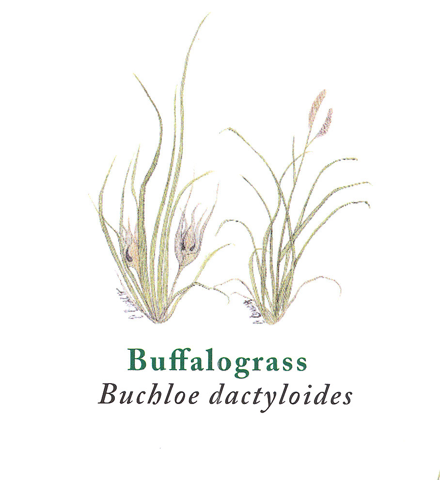
Buffalo grassThe Latin name of Buffalo grass is Buchloe dactyloides. While the words are Latin, the origin of buchloe is the Greek word “bous” which means cow. Chloe is Greek for grass. Dactyloides refers to something that resembles fingers. Buffalo grass is a very short plant with curly leaf blades covered with fine hairs on both the upper and lower surfaces. The leaves are gray-green. The grass tends to lay down and where it touches the ground it may send out a stolon, or new root. Some scientists call this plant Bouteloua dactyloides. is classified as a short grass that spreads by sending out new shoots (stolons) underground. (See Image 2) On the soil surface, this grass forms dense bunches or mats. Buffalo grass is also classified as a warm season grass, meaning that it reaches its maturity in the warmer months of summer. This grass is drought tolerant and actually increases when it is heavily grazed. Grazing does not harm the grass; buffalo grass improves under normal grazing conditions.
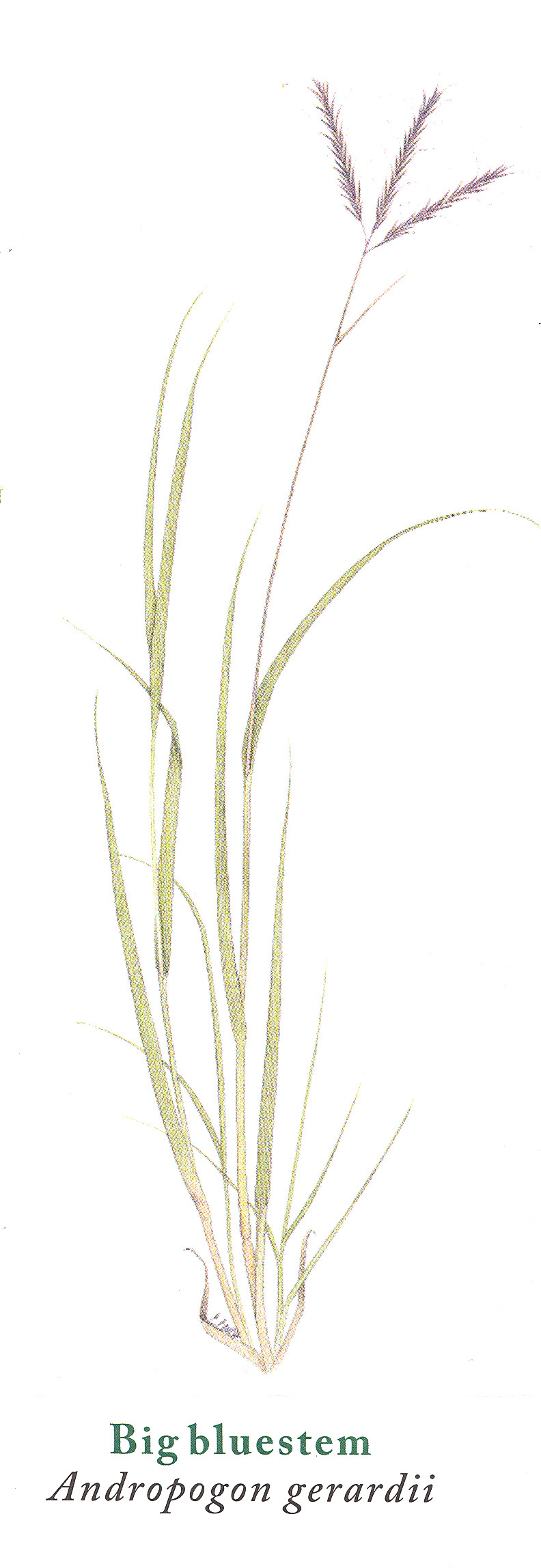
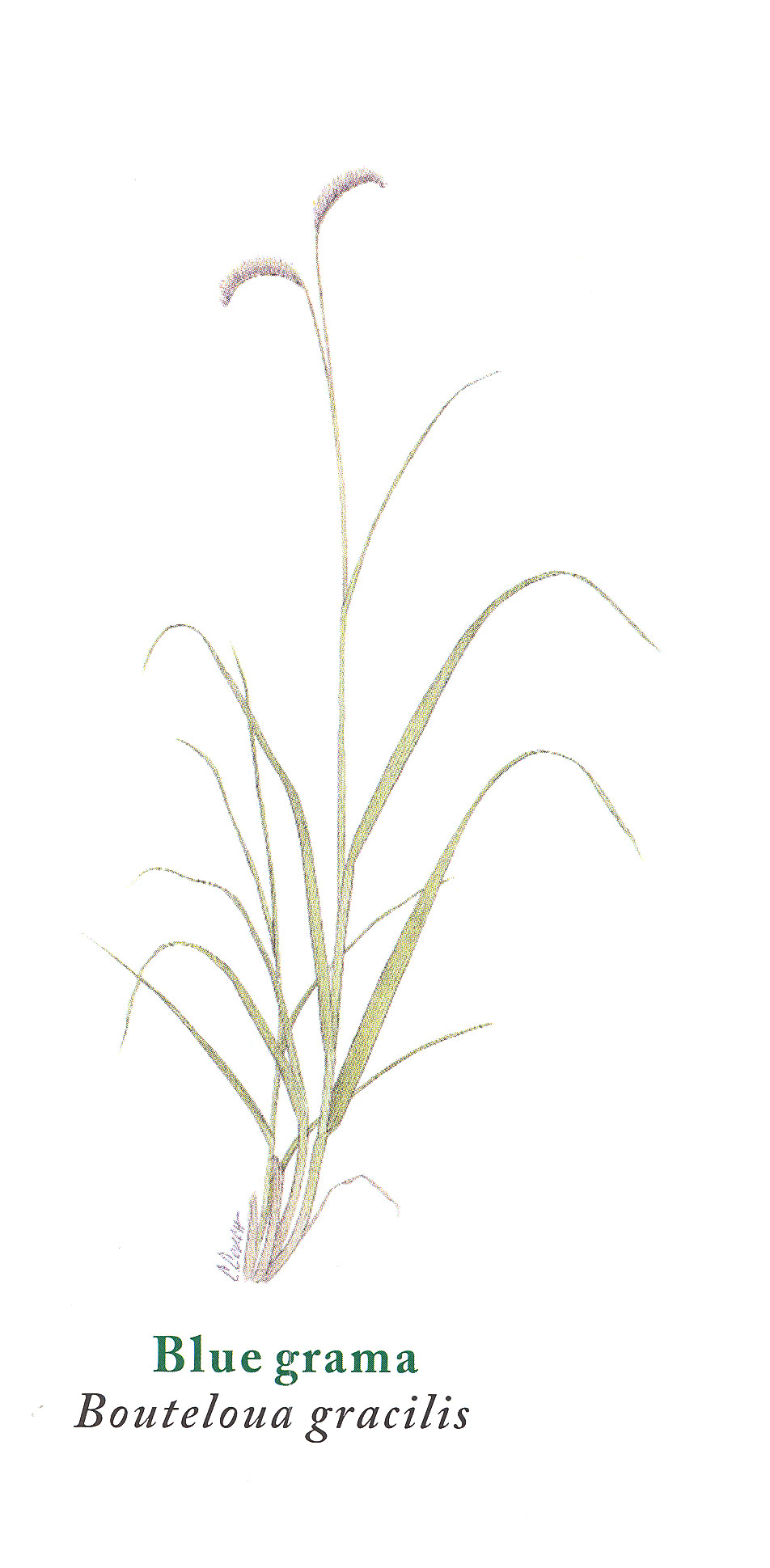
Buffalo grass is unique to the Great Plains. It is found in all parts of North Dakota, but it is more abundant in the western part of the state. Of course, buffalo grass is not the only grass on the plains. Dozens of varieties grow well in the grasslands of the Great Plains. Tall grasses grow abundantly in the eastern part of the state, while short grasses, such as grama grasses, (See Image 3) are more likely found in the western part of North Dakota. Tall grasses include big bluestem (Andropogon gerardii), (See Image 4) Indiangrass (Sorghastrum nutans), and switchgrass (Panicum virgatum).
Scientists have found that buffalo grass is very nutritious for animals, as Rothhammer reported. Cattle and sheep, as well as wild animals such as deer, jack rabbits, and antelope graze this grass. Beef calves grow well on a diet of buffalo grass. The mature grass “cures,” or dries, on the stalk and retains its nutrients in the dry plant material. Eugene Marshall thought this was unusual because the eastern grasses he was familiar with tend to rot when their growing season is over.
Wild birds also like buffalo grass. Prairie birds, such as the McCown’s longspur, eat the seeds. Snow geese graze on the young plants in early spring when they migrate through the region.
Prairie fires do not harm buffalo grass. The stolons, or roots, running as much as five feet below ground, are protected from fire by the soil. The seeds are encased in burs that resist fire. After a prairie fire burns an area, the stolons go back to work sending out new shoots. The tender young grass that grows after a fire is very tasty to animals.
Why is this important? The native grasses have deep roots that hold the soil and prevent wind and water erosion. The nutritious grasses fed the bison that fed the American Indians who lived or hunted in this region. Today, the same grasses provide feed for cattle on many farms and ranches. Cattle provide beef for people who live in cities.
Many scientists believe that the huge grasslands of the Great Plains, like the great forests of the Amazon River basin in South America, help to clean the air and reduce harmful chemicals in the atmosphere. Some farmers, ranchers, and homeowners today are restoring the native prairie with grasses such as buffalo, grama, and big blue stem in order to reduce erosion and provide livestock and wildlife with food and shelter. Lawn specialists recommend buffalo grass to homeowners as a short, sturdy lawn grass that needs little mowing.
Buffaloberry Bushes
L. M. Rothhammer wrote that buffaloberry (Shepherdia argentea) shrubs (See Image 5) would make a good hedge because they are thorny and “stock will not browse on it.” They grow in poor soil and are seldom bothered by insects. The berries produced are small, but tasty, so he said.
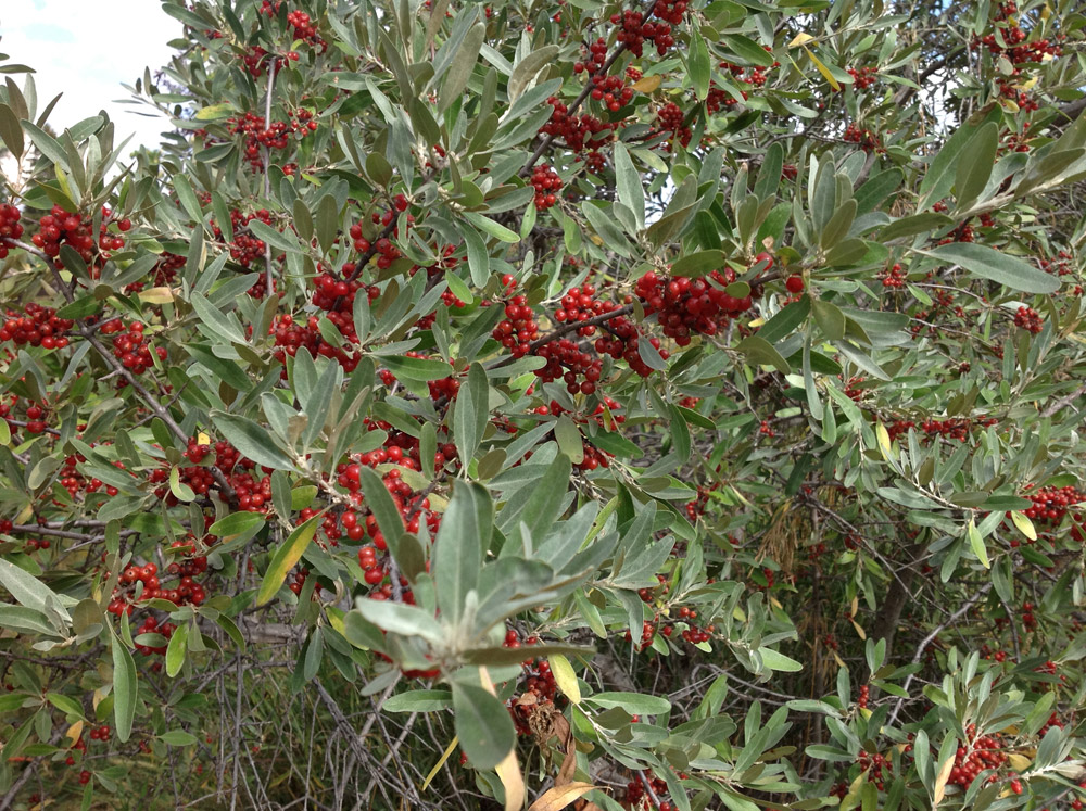
The buffaloberry (sometimes called bullberry) is, indeed, a hardy, thorny shrub with silvery leaves. The female plants produce small, bright red berries in tight bunches on the ends of the branches. The flavor of the berries is perhaps not quite as enjoyable as Rothhammer declared. The berries are very tart until after a good frost when they sweeten a little.
Rothhammer was interested in the buffaloberry because he thought Dakota would be a good place to raise livestock. In Rothhammer’s day (before barbed wire was widely available), many farmers would plant a thick hedge of thorny shrubs to keep cattle in a meadow. It appeared to Rothhammer that Dakota had everything necessary—nutritious grasses and thorny shrubs—for livestock industry.
The men of the Lewis and Clark expedition ate buffaloberries in the fall of 1804 – after frost. Sergeant Ordway wrote in his journal
“we found a large quantity of Graze the Buff. Or Rabit Berryes of which we eat freely off. They are a Small red berry, Sower & Good to the taste. We have Seen them pleanty in this Country.”
Rabbit berry is another common name for buffaloberries. It is easy to spot a bunch of buffaloberry bushes from a distance. The leaves are a soft gray-green color. In the fall, when the berries are ripe, the bushes appear to have bright red spots on them.
Today, buffaloberries are often collected in the wild or from gardens to make jelly. American Indians used them in their cooking as well. The bushes produce fruit reliably, even in dry years. However, the quantity of berries will vary with growing conditions. Some people say that they can tell that the coming winter will be harsh if the buffaloberries are quite abundant on the bush. If the fruit is not abundant, the winter will be mild.
Why is this important? Buffaloberries, like chokecherries, juneberries, and plums are native to North Dakota and have provided people with nutritious and delicious food for centuries. Early European American explorers and settlers understood how important it was to have readily available sources of food, especially those that provided health-giving Vitamin C. American Indians knew the value of these fruits and harvested them for use in their meals in late summer when the berries were ripe. Indians dried the fruits for later use in the winter. When pioneers arrived in the late 19th century, they looked for native fruits and other plants to supplement their small food supply. As the pioneers became settled, they planted familiar fruits, such as apple trees, and left the buffaloberries to the birds.
Bison
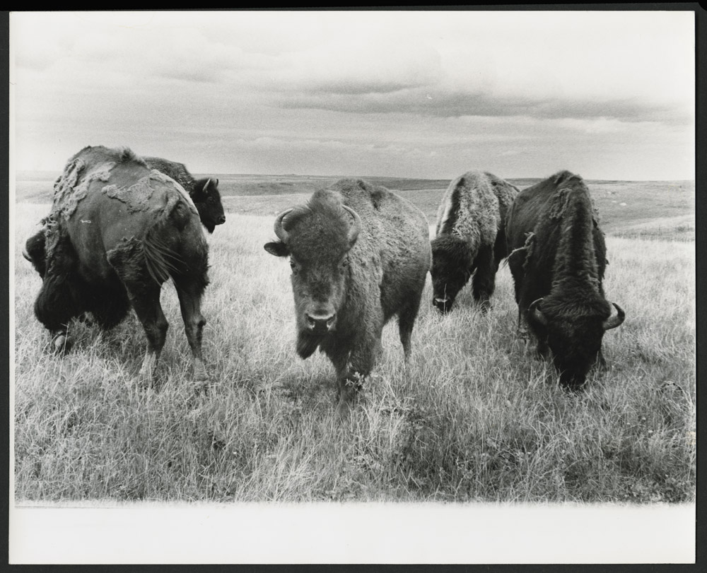
What L. M. Rothhammer described in his report was an ecosystem, a place where living organisms such as plants and animals interact with non-living elements such as soil and climate. One of the most important parts of the northern plains ecosystem was the great herds of bison (See Image 6) that roamed the grasslands.
Rothhammer does not describe actually seeing bison,Is it bison or buffalo? We use both words to refer to the great, shaggy, even-toed ungulate. The Latin name,
The bison fed year around on the nutritious grasses of the northern Great Plains. In large herds, bison migrated across the plains finding water and fresh grass as they needed it. In winter, the herds sheltered in the woods along rivers. With their heavy heads, bison brushed away snow to reach the grass. Their constant grazing helped grama grasses and buffalo grass to spread and form dense, moisture conserving sod. This biological response served the bison well. If a little rain or snow fell after a herd of bison had grazed one area, the grasses grew again to feed the next herd of bison that wandered by.
Heavy, strong, and fast runners with a thick coat of hair, bison were well-protected against natural enemies. Prairie wolves and grizzly bears preyed upon old, sick, or very young bison. Mature, healthy bison could fend off most predators. Human hunters, however, forced entire herds of bison to run over cliffs where they were injured and then killed by the hunters. Later, humans used spears, bows and arrows, and eventually guns to kill significant numbers of bison. The bones remained on the prairie to fertilize the soil and feed scavengers such as coyotes, rodents, and birds.
Other animals also grazed on the plains including massive herds of elk, deer, and pronghorn (antelope.) The ecological balance of the grasslands changed when horses came to the northern plains in the mid-18th century. Horses, both wild and domestic, grazed the same grasses. However, horse-mounted hunters could kill more bison, more quickly than could hunters on foot. Horses gave the Lakotas, Dakotas, Chippewas, Mandans, Hidatsas, and Arikaras more food security.
Why is this important? Bison herds, numbering perhaps several tens of millions, helped to maintain a balance among the plants, animals, and people who lived on the Great Plains. Twenty years after Rothhammer wrote his report, the bison were absent from the northern Great Plains and had come close to extinction. Hunting for eastern industrial markets (rather than local food supply) and the need to secure the land for agriculture and domestic cattle meant the end of the great bison herds. When the bison were gone, Indian tribes had no choice but to accept life on a reservation.
Burning Coal Vein
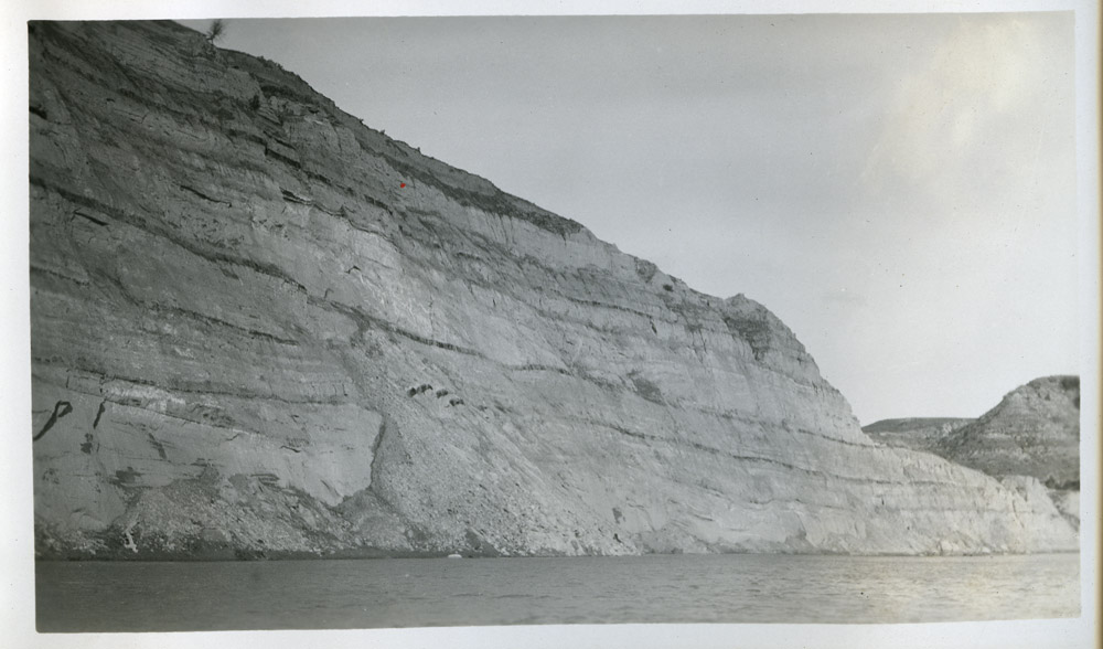
One of the most important geological features in Rothhammer’s report was the Great Lignite Basin of northern Dakota Territory. He attributed the thinning of the coal veins (strata) to “spontaneous combustion.” (See Image 7) Actually, the veins naturally vary in thickness. William Clark also noticed coal outcrops along the Missouri River during his journey upstream with the Corps of Discovery. Clark’s journal entry on March 21, 1805, indicates that he noticed that the coal veins had once burned. Clark described the “marks of the hills having once been on fire.”
Exposed surface coal can be ignited by prairie fire or a lightning strike. There is also the possibility that the fires were started by a chemical reaction in the coal. Where pyrite and iron sulfide (also called marcasite) combine with moisture, the reaction produces heat. If the chemical reaction causes the temperature to rise to the point of combustion for coal, 9790 Fahrenheit, the coal vein will burn. When the coal vein is near the surface, especially if there are enough cracks to allow air near the burning lignite, the fire will burn hotter. Smoke rises from the opening. Most burning coal veins, however, suffer from a lack of oxygen and burn very slowly. The coal vein might burn at a rate of only 10 feet per year.
Burning coal veins turn to ash when combustion is complete. Then, the earth above cracks and falls into the empty space below causing a sink, or slope, in the appearance of the surface. The collapse of the surface allows more air into the burning space which keeps the fire going.
There are two major effects of the burning coal. One is the creation of clinkers or, as we mistakenly call this stone, scoria. The clinker material is bright red, yellow, or black rock. Clinkers are very hard because they are baked by the heat of the coal vein fire. When clinker covers a hill, it resists rain and wind erosion. Mesas form where erosion has washed away the softer rock and soil around a clinker deposit.
Gases that rise from the burning coal drift with the wind into forests of junipers that typically grow in western North Dakota. The fumes, a type of air pollution, cause the junipers to grow in a tall columnar shape. When the burning coal vein smothers or moves away from the junipers, they resume their normal bushy shape. (See Image 8)
Why is this important? Burning coal veins cause very little concern to firefighters in North Dakota. It is possible that in a very dry year a fire in an exposed coal vein might ignite a prairie fire, but most burning coal veins smolder deep underground and do very little damage on the surface. When a coal vein nears the surface and visitors can see the smoke, the site often becomes a tourist destination. (See Image 9)
Burning coal veins created “scoria,” or clinker, which is commonly used as a road surfacing material in western North Dakota. Scoria has a pink or light red color. It is hard and resists wear as a road surface. Burning coal veins, also explain why North Dakota’s landscape is shaped by mesas, columnar junipers, and slopes in coal country.
Grasshoppers
L. M. Rothhammer wrote about the devastation that grasshoppers brought to the grasslands in 1865. He wrote in a period of great heat and drought, which allowed grasshoppers to multiply. There are fewer grasshoppers in years of heavy rainfall when grasshopper eggs are washed away before hatching.

Rothhammer’s report was generally favorable to the grasslands. However, he raised a note of alarm when he wrote that “grasshoppers had stripped large tracts entirely of [grass,] gnawing the blades close to the root . . . .” Farmers who read that portion of his report would have worried that they would not be able to raise a grain crop under those conditions.
A few years later, General Regis de Trobriand, met great hordes of grasshoppers at Fort Stevenson. The soldiers did not raise wheat, but they tended gardens that were supposed to provide them with life-saving vegetables during the long winter at the post. The grasshoppers threatened the gardens. De Trobriand recorded the event in his diary on July 20, 1868:
. . . around noon, clouds of grasshoppers began to show up in the sky. A multitude of these fearful insects flew skimming along the ground, and the layers seemed to thicken as they rose in the air. In the direction of the sun, these innumerable multitudes, more visible to the naked eye, looked like a thick dust of white specks which drifted, passed each other, and multiplied in the air. Finally, the last and fatal symptom, a great murmur like the steady rumble of far away carriages filled the air all around. It was the droning of this traveling ocean of winged insects. Our gardens and pastures would be all gone if this cloud came down to earth. Two or three hours would be enough for complete and absolute devastation; everything would be devoured, and nothing could prevent it.
At this time, a black [rain] storm began to come up on the horizon to the north. Heavy clouds mounted one on the other. . . . Carried by the storm, [the grasshoppers] crossed the Missouri, and scattered far out on the plains. Our gardens and pastures were saved, at least this time.
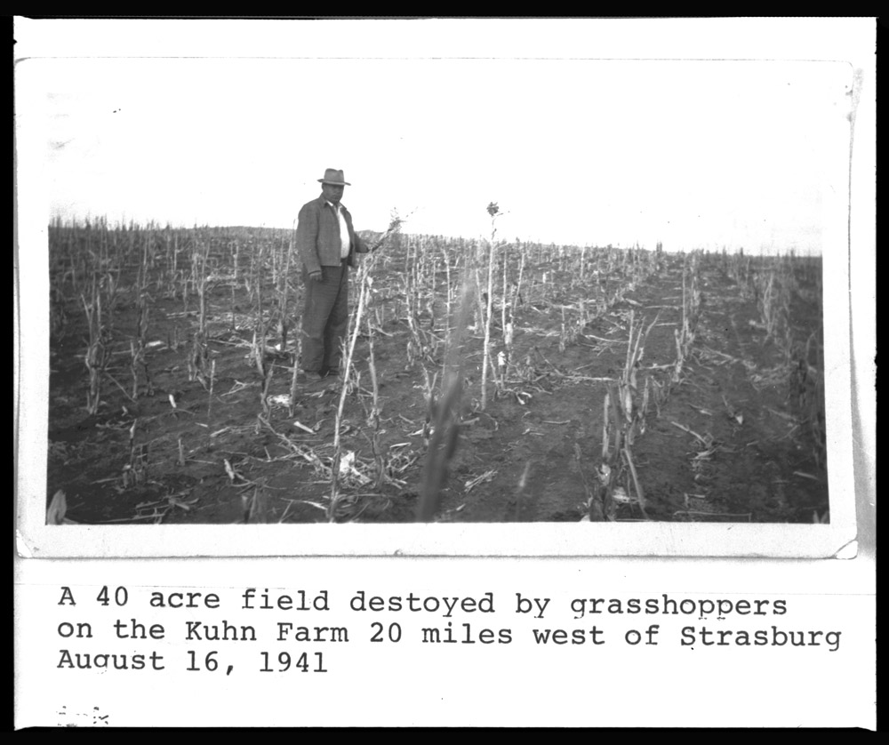
Decades later, during the Great Depression and drought of the 1930s, grasshoppers again threatened crops. (See Image 10) When the crops were entirely eaten up, the grasshoppers ate clothes hanging on clotheslines, the straw off brooms, and even gnawed on fence posts. (See Image 11)
Why is this important? Grasshopper plagues do not strike the grasslands of the Great Plains every year, but when they come, they cause great damage. Farmers who came to Dakota Territory just ten years after Rothhammer’s journey occasionally lost entire crops to grasshoppers. These insects still appear, though the application of insecticides tends to limit their numbers.